Oh that the exposure was this clear today!
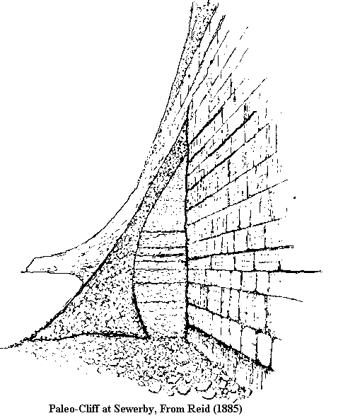
Between 116,000 and 128,000 years ago, prior to the deposition of the pleistocene tills of Holderness, the Yorkshire coast ran westwards of the current coastline running on a curving line running just to the west of Driffield, Beverley and Cottingham. Traces of the former coastal cliff can be traced, such as a slight break of slope near Harland Way, Cottingham. Where this former cliff line cuts the current coast, at Sewerby, just to the north-east of Bridlington and at Hessle on the banks of the Humber are exposures of cliff sections. At present both sections are obscured and the last really good exposure of the Sewerby cliff section was in 1953 following the great tidal surge of that year. The Sewerby cliff was excavated and described by G.W. Lamplugh in 1887. While Lamplugh dated the cliffs as "pre-glacial" further work by John Catt and Lewis Penny have dated them to the last interglacial (Ipswichian (=Eemian))
The Hessle cliff was noted by John Phillips in 1825 and a good exposure was made accessible by the construction works of the Hull and Selby Railway in 1840. It was exposed again some time at the turn of the (nineteenth) century and was described by W.H.Crofts.
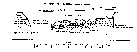
The Hessle Buried Cliff
Drawing of the Hessle Buried Cliff as it appeared at about 1900 by W.H.Crofts.
In 1983 the old bridge was demolished and extensive excavations were made as part of the new South Orbital Road and the site was examined by members of the Hull Geological society.
The Hessle exposure is considerably smaller than the Sewerby exposure with a vertical face of 2.5m. The base of the Hessle cliff is higher at +7.95m. O.D. than the Sewerby cliff whose base is close to that of the modern cliff.
The line of the cliff at Hessle runs North-East to South-West. It is possible that this discrepancy is nothing more than the kind of difference noticed in the modern cliffs between Sewerby and Speeton. Alternatively a tectonic change could be the reason. Catt and Penny suggest that the Sewerby cliff was eroded in two stages and the Hessle cliff may have escaped the first phase.
The solid chalk of the beach slopes away to the south and is covered by the beach deposits. These consist of a basal layer of large water worn chalk stones overlain by a layer of smaller water worn chalk stones with the interstices filled with sand. Two eratics, one of basalt and one of brown chert were found along with two bone fragments that did not survive extraction. A fragment of shell of Buccinum undatum was also found in the beach deposit.
Above the beach deposit was a layer of 'landwash'. Above this was a deposit of fine, rounded grains of wind blown sand 10cm and in one place 20cm. thick. In the lower, almost horizontal part water-worn valves of Macoma (Tellira) balthica were found. The lower part of the sandy layer was topped by a thin layer of dark brown silty clay with small pebbles. This layer extended over the top of the cliff. K Fenton interprets this as a possible paleo-soil. Above this is a chalk and flint gravel layer, interbedded with sandy streaksup to a few cm. thick interpreted as solifluxtion deposit. The upper part of the section was obscured but a silty band about 2m. thick could be seen below the covering boulder clay. IN a later stage of the excavation a section was seen where there was an almost horizontal contact between the base of the boulder clay and the beds beneath it. These beds consisted of silty layers resting on small water-worn pebbles laying above the solifluxion deposit.
After the cutting of the cliff and the formatin of the beach deposits during the Ipswichian interglacial the colder glacial stage caused a lowering of the sea level. Landwash coming over the cliff accumulated as the beach level retreated. The low cliff at Hessle did not allow as much wind blown sand to accumulate as the much higher (10m.) cliff at Sewerby. The presence of fossils of CardiumandMacoma (Tellina) indicate the close proximity of the estuarine conditions of Humber. The 'Head@ overlying the sand, with more sand included in it is a solifluxion deposit formed by freeze-thaw action in periglacial conditions on a downward sloping surface with sand becoming included as it was added by wind action. The layer of small water rounded pebbleds are a product of the wet conditions in front of the ice sheet advancing from the east, streaks of 'drab' clay(indicating Skipsea Till) from the ice front represent a transitional stage . In the final stages before the cliff was overrun by the ice the humber became dammed with ice and creating Lake Humber to the west. This resulted in the deposition of the silty layers which had an almost varve like appearance. The curious flinty layer near the base of the silt is difficult to explain. The top of the silt dips slightly from north to south but is almost horizontal on an east-west axis. K Fenton suggests this undisturbed contact with the overlying boulder clay may be the result of the ice pushing over a frozen lake surface which protected the underlying layers.
References
The above is largely taken from an article in "Humberside Geologist" by K Fenton.
Catt,J.A. and Penny, L.F. 1966 The Pleistocene Deposits of Holderness Proc.Yorks. Geol.Soc. V35 pp37755-420
Crofts. W.H. 1906 Notes on the indication of a Raised Beach at Hessle. Trans. Hull Geol Soc. V5 pp 58-64
Lamplugh. G.W. 1898Report on the Buried Cliff at Sewerby near Bridlington. Proc Yorks Geol. Soc. V9 pp381-392
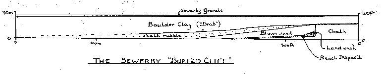
When exposed (a rare occurrence) an interglacial shingle beach can be seen about 1 m. Above the modern beach and resting on a planed surface of Basement till, probably of Woolstonian age ( about 140,000 years age. The raised beach contains vertebrate remains including straight tusked elephants Paleoloxodon antiquuus, Narrow nosed rhinoceras Diceroorhinus hemitoechus and Hippopotamus dating the beach to the last (Ipswichian) Interglacial. Banked against the cliff is rainwash and over this is blown sand representing deposits of the encroaching Devensian (last) cold period accumulating as falling temperatures and increased glaciation caused a drop in sea level permitting deposits to accumulate at the now stranded cliffline. As the ice covered the cliffline it deposited the overlying Skipsea till, itself overlain by the Sewerby Gravels which are glacio-fluvial in origin and contain both mammoth bones and human artifacts.
The cliff is important in that it demonstrates that the Skipsea till, which in Holderness rests directly on the Basement till represents deposition in two seperate glacial episodes with an interglacial period inbetween.
References:
Richard Myerscough.The Chalk of Flamborough Head inScrutton, Colin. 1996 Yorkshire Rocks and Landscape Yorkshire Geological Assn.
Peter Rawson. The Buried Cliff in Rawson, Peter F. and Wright, John K. 1992 The Yorkshire Coast: Geologists Association Guide no 34. p. 100
Return to the
East Yorkshire Geology and Geomorphology Homepage