This year we opted to try to outdo our previous trip of insanity from a couple of years ago. In the fall of 1998, we paddled 50 miles down the Green River in Utah to the confluence with the Colorado River. At the confluence, we turned up the Colorado River and spent 6 days paddling, poling, pushing and dragging our canoe 50 miles upstream to the town of Potash, where we'd had our truck driven. The trip had all the elements of a true adventure. It was new territory for us, it was physically demanding, had that emotional uncertainty as to whether or not we could do it, had a perceived element of danger (such as when our canoe and tent tried to blow away, stranding us on an island) and the terrain we passed through was outstandingly beautiful. It was really tough. We decided after the trip that we wouldnt ever do it again, at least not in a canoe. Maybe in sea kayaks though
After a couple years for amnesia to set in and for the knots in our backs to go away from paddling upstream, we decided it might be fun to try to do something unusual again. I came up with the idea that we could pedal our bikes over four of the highest jeep trail passes in the Rocky Mountains. The trip forms a loop in the San Juan Mountains, between the old mountain mining towns of Silverton, Lake City, Ouray, Telluride, Ophir, and back to Silverton, crossing four 11,000 to 13,000 foot passes; Cinnamon, Engineer, Imogene, and Ophir in the process. It's been called "The Credit Card Ride" as it's normally done by riding with minimal gear (warm clothes and lunch) from one town to the next, staying in B&B's and eating at restaurants. Done this way, it takes four to five very long days, depending on the weather and the riders' stamina.
We opted to take some of the money that we would have spent on B&B's and restaurants, and spend it on two B.O.B. bicycle trailers instead. The B.O.B. trailers are single wheeled. They hug the ground and track behind your bicycle well enough to allow you to ride single track-width trails with up to 70 lbs of gear. Our idea was to take 9 days to do the trip, pulling all of our camping gear behind us in the trailers, camping out each night. We had never heard of anyone doing this, and there is probably a good reason why, but we reasoned, "What does adventure have to do with being reasonable?"
We started preparing for the ride a couple of months before by riding a couple of nights a week after work, as well as on the weekends. Our weeknight ride involved pedaling a couple of miles through town from our house to Little Park Road, which switchbacks up the side of the Grand Valley. We would then pedal 3 miles or so up the switchbacks, watch the sunset colors across the valley, then tear back down the road at high speeds, scaring the jimmies out of various small animals as well as ourselves. We started doing this without trailers, then pulling empty trailers, and then kept adding payloads to the trailers until we were grinding up the hill pulling trailers with 5 gallon jugs of water in them, then doing it all in the middle chain ring. I'm sure the residents on Little Park Road thought we were nuts. We know this because one of them is my boss, and he pulled me aside one day at work to tell me he thought I'd lost my marbles. It's possible he and his neighbors were right, but it was nice to feel our legs gradually grow stronger each week.
Meanwhile, in her "spare" time between work, grinding up the hill on her bike, weekend trips, and weeknight martial arts classes, Jeanne was dehydrating veggies and fruit. She also prepared hundreds of small ziplock baggies with dinner, lunch and breakfast entrees for the trip, most of them taken from a book called "Simple Foods For the Pack", our new favorite for backcountry recipes. All of the recipes are made from simple bulk ingredients, and most are very good. The book also has a large number of backpacking deserts, and many involve baking, so we also purchased a backpacking oven and diffuser plate, to allow us to cook cakes and breads on the trail. The oven is very light. It consists of an aluminum, teflon lined baking pan with a lid that features a baking thermometer, and an inflammable fabric "tent" that sits over the stove and baking pan, to hold the heat in. The tent has a hole in the top so that you can see the baking thermometer on the pan.
I set up the bikes to pull the trailers, installing rear cassettes with a 34 tooth "granny" gear, new chains, front sprockets, brake pads, and rear tires. We also opted to replace our clip in pedals with old cage style pedals, custom stretched with a propane torch to allow us to fit our lightweight hiking boots into the pedal cages. We reasoned that if we got into cold weather or had to do a lot of pushing or walking, the lightweight bike shoes wouldn't work as well as hiking boots with wool sox. This proved to be a good choice.
We rode on the weekends as well. A couple of weeks before the pass to pass ride was to start, we spent three days on a trial run, pulling the 50 and 40 pound loaded trailers over a 2000 foot climb on old jeep roads in the Elk Mountains to a secluded alpine basin near the Maroon Bell peaks. We were astounded at how tough it was, despite our training rides and super low gears. We had to get off and drag the bikes up several portions of the climb, and found that pushing was as tough as riding. We seriously discussed not doing the pass to pass trip, then decided to try it, with the condition that we could always short-cut back to the car over 11,000 foot paved Red Mountain Pass after the first two jeep passes if things weren't going well.
Day One
On September 1st, after months of preparation and anticipation, we drove down to Silverton on a Friday night, camped in a rainstorm, and woke up on Saturday to snow on the peaks above us.
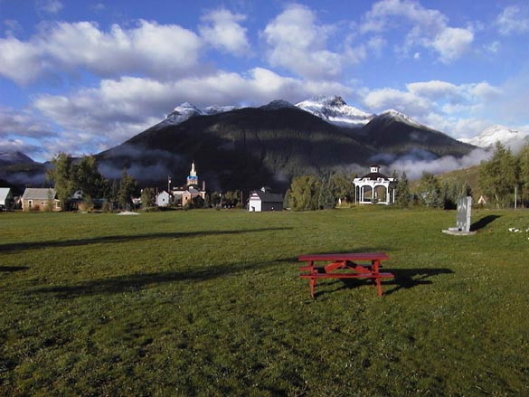

Silverton Town Park
Click on any image to see a larger version!
After drying out our tent in the sun in the Silverton town park, we headed up the road toward Cinnamon Pass. We were hoping to do 10 miles or so to just past the town of Eureka and go over the pass on Sunday morning, but after arriving at Eureka by noon, decided to continue climbing.
Climbing out of Eureka
We stopped for lunch near a former mining town called Animas Forks, where we noticed there were several public outhouses set up. I asked Jeanne why she thought they might need so many outhouses, and she responded it was "because everyone was getting enemas in Animas, Hah!"

Climbing past Animas Forks
While we were parked beside the road eating a snack under our space blanket to stay dry during a brief rainshower, two enormous new Ford Expedition SUV's pulled up, one driven by a man, the other by what was apparently his wife or girlfriend. Each had 3 or 4 dogs in the car with them, and had driven there from who knows where just to take the dogs for a short walk. Seemed to us like a bit of an excessive waste of resources (gas and dog food) for two people, but we managed to keep from snickering until they had wandered out of ear shot with their herd.
After lunch, we surprised ourselves by managing to grind our way up over Cinnamon Pass, 3300 feet higher than Silverton.

Jeanne cresting Cinnamon Pass, 12,640
Jeanne found that if she stopped to take a break on the climb, she couldn't get back on her bike on the steep slope. We developed a routine where I would help her get started by holding her bike upright while she got her feet ready on the pedals and started off, then I'd hop on my own bike to chase after her. We had some trouble with this at first until she realized that in her trepidation (caused by the fact that I would hold her bike at a 45- degree angle in my direction) she had been clamping the brakes on as I tried to push-start her.
I also found that my speedometer wasn't registering most of the mileage because with the super low gears on the steep jeep roads I was often pedaling at less than the minimum recording speed of the device, which is 1.5 miles per hour. The low weight of the B.O.B. trailers actually seemed to help us stay upright so that we could pedal uphill at ridiculously low speeds. Some of the hills just proved too steep though, and we were forced to get off and push. As it turned out later, this was our easiest pass of the trip.
At the top of the 12,640-foot high pass, the four passengers of one vehicle cheered and clapped as I crested the last steep climb. I bowed, then raced to get the camera out to photograph Jeanne pedaling up, to more applause. Donning wind jackets and winter gloves, we cruised happily on down the east side of the pass to a nice campsite just below a beautiful timber-free glacial valley called American Basin.
American Basin
That made for about 20 miles and 3300 feet elevation gain for the first day, which had us both feeling a lot more optimistic about our chances of doing more than just two passes and a tarred road back to Silverton.
Dinner that night was rice with a sweet and sour sauce that included chunks of rehydrated dried pineapples. This proved to be very good. Dessert was a custard pudding that we decided we wouldn't try again, ever.
Day Two
On Sunday, the second day of the trip, we woke up with some very tired legs. Luckily, our route for the day was to be mostly downhill. We breakfasted on delicious combination of stewed fruit, that Jeanne had previously dehydrated at home, and a seed cereal consisting of a mixture of ground seeds and nuts with maple syrup.
We headed downhill, and continued mostly downhill all the way to Lake City, elevation 8700 ft for a loss of about 3000 feet in 22 miles. That was nice! The weather was breezy and partly cloudy in the high 60's, nice riding weather.
Lake City is a mostly restored old mining town that seems to cater more to motorized outdoor enthusiasts than the non-motorized ones, and The Ironhorse Motorcycle Rally was in full swing, so we didn't stay in town long. We turned west onto the Engineer Pass Road, and, slowly, pedaled 10 miles and 1000 feet up to a small valley that is the site of Capitol City, a mining ghost town. We found a great campsite at the edge of a nice stand of young aspen trees overlooking the valley. We felt good about our 32 mile day despite the tired legs, and had some slight optimism that we might get over Engineer Pass the next day.
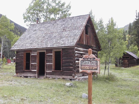

Capitol City Campsite, Day 2
Dinner was garlic broth (20 garlic cloves!?) with salmon dumplings, and brownies for dessert. Unfortunately, the salmon dumplings didn't hold together, but the meal was good. The brownies were another story. The recipe had come with the backpacking oven and we think they had reversed the quantities of flour and sugar. They were mostly sugar, and ended up buried in a hole in the meadow.
We spent the rest of daylight lounging, reading library books that we had taken out for the trip. For many of our longer trips we've taken to reading novels by Michael and Kathleen Gear. As archeologists, they've attempted to popularize North American archeology by creating fictional stories about each of the major tribal regions on the North American continent. The stories all have shamanistic themes, but are a good introduction to how the different Native Peoples lived before Columbus. Reading these books always seem to go well with being immersed in the outdoors on long trips.
Day Three
On Monday, we had a leisurely, tasty breakfast of buckwheat groats with rehydrated apricots and maple syrup, topped off with hot chocolate. A hummingbird paused to inspect our colorful gear, and a small hawk observed us for a few minutes from a tree above our campsite.
We started up the road again towards Engineer Pass. It didn't take us long to decide on an easy day. I was having stomach problems and my legs felt like jelly. Jeanne wasn't opposed to the idea of cutting the day's ride short for some serious high mountain rest and relaxation. After just over 5 miles and 1100 feet of elevation gain, we found a spur road leading to an isolated meadow complete with a stream and beaver pond, ringed on all sides by high mountains. We set up our tent, and lounged on a space blanket in the meadow, alternating between reading and watching the wildlife and the colors change on the peaks as clouds passed over.

Campsite Day 3
We also visited the beaver pond, and attempted to draw the beavers out by removing a few sticks from one portion of the dam. I know, sounds mean but I think I read about this in an Aldo Leopold book as a way to observe beavers in their dam building mode. Aldo must have been more patient than us though. The beavers out-waited us, and we returned to our space blanket. Towards late afternoon, we heard a loud sneezing sound, and looked up to see a surprised white tailed deer hopping back and forth in front of us. Apparently, she'd ambled out of the bushes across the road and panicked when she saw us, finally bounding back into the bushes along the stream.
As the sun set, we were forced into the tent by one short but noisy thunderstorm and shower, then came out to see the sunset light up the peaks.
We had a good dinner of lentils in a tomato soup, which seemed to sooth my upset stomach. After dinner, we took turns with the monocular, watching mule deer browse on an avalanche-cleared slope across from us. We were also visited by a very large, dark brown rabbit, several gray jays, stellar jays, and both large (red tailed) and small (Sharp-shinned?) hawks. The chance to take a break, relax and watch the natural world for awhile made it a special day for us. We both felt very lucky to be doing the trip.
Day Four
On Tuesday, I woke up to find my stomach problems gone, and legs feeling strong again. We had a quick breakfast of granola and hot chocolate, packed up and were riding before 9:30, which for us, is amazingly early. We had brought the light tops to our bags for this trip to save weight, but with nightly frosts, they were proving marginally warm enough. Our feet particularly would get cold, and we always found it difficult to motivate ourselves out of the tent much before the sun could rise high enough to shine down into the valleys we were camped in.
The road was steep, but for the most part not unridable.


Climbing up towards Engineer Pass
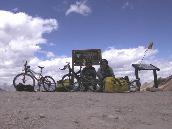
We cranked our way through a large herd of domestic sheep at treeline. I stopped to take a couple of pictures of the herd for a coworker to help fuel a running office joke (no explanation will be provided, sorry!) We cranked past one false summit after another. The skies stayed mostly clear, but the wind blew harder and harder and had a cold bite to it. Several times the wind knocked us sideways, ending our progress until the gusts would let up. After 5 miles and 2200 feet of climbing, we reached Engineer Pass,

Engineer Pass, 12,800
only to discover that the road continued to climb! Technically it is a pass, but to get down the other side, you need to continue up and around the slope on one side first. Grumbling, we continued up and were rewarded with some outstanding views of the Sneffels Range to the northwest, Wetterhorn, Matterhorn and Uncompaghre Peak to the northeast, and a large raincloud approaching from the west. We decided we'd better get down to Ouray before the storm if we could.

Windy spot above Engineer Pass, with view of Sneffels Range in distance
From 12,800 foot Engineer Pass down to the town of Ouray, you lose 5000 feet in 12 miles, most of it on a very steep jeep road, but the last few miles are on paved Highway 550 coming down from Red Mountain Pass. In my haste to reach tree line before the rain reached us, I cruised past an intersecting jeep road without noticing the sign pointing to Ouray. I was headed down a jeep road that would have brought us back to Silverton, several days early. Jeanne behind me yelled for me to stop without success. Putting her entire being into a final "LIIINNNCOOOOLLLLN!", she managed to attract my attention and get me turned around, to the relief of both of us.
We stopped for a quick lunch overlooking a small mining ghost town, and were visited by a very tame gray jay, who would land on my hand and head to eat crumbs.


Tame Canadian Jay Old Mining Town near tree line below Engineer Pass
Afterwards, we managed to get most of the way down to the highway before the rain really got going, and then blitzed down Highway 550 in an increasingly insistent rainstorm. We found a free campsite on a mining road a few switchbacks above town, and settled into the tent with our books until the rain let up. Looking at the map, we figured that we had traveled 17 miles that day, with 2200 feet of elevation gain and 5000 feet of elevation loss.
As the rain tapped insistently on our tent, we discussed options for the remainder of the trip. We had used up four of our nine days doing two passes, and hadnt really had a full rest day yet. If we rested here the next day, we would have four days for two more passes, one of which entailed a climb of over 5000 feet. If the weather turned bad, we could be stuck on the wrong side of the mountains from our car with no way to get back to Grand Junction in time for work on Monday. We decided to try to ride halfway up Imogene Pass the next day instead of taking a rest day. The day after we would try to get over the pass and down to Telluride, and then take a day off before climbing the last pass.
After the rain let up, we cooked up a cornmeal-mung bean stew for dinner that tasted much better than it sounds. For dessert, we hiked down an abandoned hiking trail into the town of Ouray, and aimed straight for the ice cream parlor. Two chocolate chip shakes later, we lurched happily across town to the Wiesbaden Lodge, which has a natural hot springs spa.
For $10/each, we received two towels and a pass to use the spa for up to 3 hours. We started out with hot showers, then cold showers, then a trip into the steam vapor cave and hot springs pool. The vapor cave appears to be the front end of an old mining tunnel that struck hot mineral water. Extremely hot water pours down the walls, creating mineral formations en route to a two- foot deep concrete soaking tub. The tub thermometer measured 107 F at the cool end where a garden hose was injecting cold water for tempering. The soak felt wonderful, but due to the hot moist air in the cave, required a trip back out to the showers for a quick cold water dunking. After enjoying the vapor cave and tub, we meandered upstairs to an outdoor swimming pool that is kept at 104 F. Its an amazing feeling to stand outside in the cool mountain evening air until you are shivering and then dive head-first into hot springs water. We repeated the chill and soak routine several times hoping that the light rain showers that had reappeared would let up soon.
At the first sign of a let up in the rain, we changed into dry clothes and headed back up the mountainside with our headlamps seeking out the faded switchbacks in the neglected old hiking trail. It started raining for real the minute we started climbing, which was a mixed blessing in that it kept us cool while exerting, but soggy. We speed-hiked to the tent, changed into dry clothes again, and drifted off to the steady patter of raindrops on the tent fly.
Day Five
On Wednesday morning, we woke early, hoping to cycle down into town for breakfast, then to the post office to pick up a food package mailed to ourselves care of General Delivery, then to start up the Imogene Pass jeep road. Unfortunately, the first sound to reach our ears on waking was the same sound that had lulled us to sleep, "pitter patter patter pitter pitterpatpatpat!" Out came the books and off we drifted into vivid descriptions of Anasazi Indians living in four and five story cliff dwellings in the desert southwest and pre-Ute tribes in the high Rocky Mountains.
Finally, the rain stopped and we hopped on our bikes and sped down the switchbacks into town. After asking around a bit, we headed for The Mountain Garden for breakfast. We knew it was the right place after reading the help wanted sign out front. "Help Wanted. We need a full time, year round employee to work 6AM to 2PM 5 days a week. The pay is $9 to $13/hour and includes two weeks paid vacation each year. Must work hard and at least tolerate The Grateful Dead; preferably enjoy them." Well, the menu looked good too. As we walked in, we were greeted with Jerry Garcias voice warbling from the sound system. They apparently play nothing but the Grateful Dead. To top it off, all of the tracks seemed to be quality bootlegs from Grateful Dead concerts. We were in Deadhead heaven, especially after our huge tasty breakfasts arrived.

Help wanted, if you like the Grateful Dead
From reading this trip write up (if youve succeeded in making it this far J ), youre probably noticing our obsession with food while traveling. Its just that when were outdoors and exercising all day long, food becomes so much more interesting than it is after a long stressful day at the office. Life becomes so much simpler and engaging. Sleep, wake up starving, eat, spend the day reveling as you travel through an infinite variety of constantly changing outdoor sensory stimuli; sights, sounds, smells, temperatures, textures, tastes. Get hungry again. Eat again, stomach very happy. Its great! Why did we ever bother evolving from hunter gatherers? Oops, sorry, back to the trip.
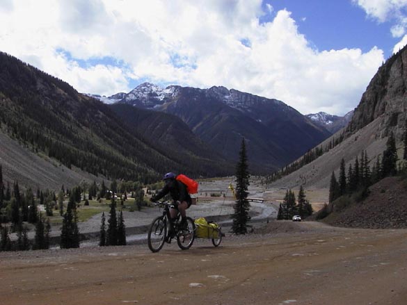
After errands in town and another light rain shower, we packed up and headed up the Imogene Pass Road at 2 PM, possibly a new record for non-early starts for us. We had intended to make it a semi-rest day by riding only 4 or so miles and a gradual thousand feet of elevation gain in nice weather. We ended up climbing 2400 feet in 8 miles, on top of the 300 or so feet from town to our campsite, in sporadic rain showers, but it was still a heck of a lot more fun than a good day at the office! We stopped a couple of times to hang out under trees or rock overhangs under our tarp and snack on the various lunch items Jeanne had made.
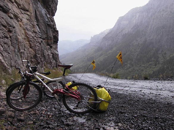

Rainy pit stop Those mining roads, if you cant go around, go under!
These included peanut butter fudge, a spicy nut and seed mix, fruit pemmican, journey cakes, home made graham crackers, home made wheat crackers spread with peanut butter, anzac cookies and a wheat-almond-maple syrup cookie. We also had Cliff Bars, tubes of Gu, and Gatorade for quick energy.
At one point, I remember gazing across the gorge and being amazed at how beautiful everything was, as we sat snuggled under our space blanket under a rock overhang. Brilliant green vegetation clung to cracks and ledges on a 500-foot high cliff face across the gorge. Stone, black and shiny with moisture rose up to meet dark green slopes of Englemann Spruce and grassy avalanche runs, topped by gray talus slopes leading up to high summits. Misty rain slanted down into the bottom of the canyon where a brilliant white cascade thundered. I felt like I could sit there forever. Heck, anything to get out of having to peddle up a 20-degree pitch pulling a loaded trailer! People would splash by us in jeeps, peering at us curiously and sympathetically through water and mud specked windows. I could imagine them thinking about how miserable we looked, while I was wondering at how paradoxically happy I was.
As usual, we were extremely choosy about our campsite selection, and didnt get a site picked out and the tent set up until dusk. The rain was light but clouds coming down the valley looked ominous, so we set up a front porch off the tent using our space blanket, parachute cord, and the little fiberglass flag poles that came with the trailers. We had a great open view up and down valley. We bundled into polypro long underwear, pile jackets, down parkas, rain pants and hats for warmth, and sat, cozy and protected from a light rain, under our porch roof to cook and eat dinner. It was meditative and peaceful watching the clouds, white against the dark mountains, drift down the valley, and to listen to the stream cascading through a small gorge beside us, with the little gas stove hissing steadily. Nothing to do but stretch tired legs and wait for a hot dinner, and to anticipate burrowing down into a soft sleeping bag for the night.
For dinner we had a nice hot Salsa Soup with Dumplings (the dumplings didnt fall apart in this one), and baked Spice Cake in the Backpacker Oven. The soup was good, the dessert was like finding a five star restaurant in the middle of the wilderness. Spice Cake is a whole wheat cake with cinnamon, allspice, nutmeg, cloves, walnuts, raisins, chopped dried apples, honey and vanilla. Its very, very good.
Day Six
On Thursday, we woke to clear skies. Eager to try to get over the top of Imogene Pass, 2600 feet and several miles up, we were packed up and riding by 9:40 AM, after a quick breakfast of granola and leftover spice cake with hot chocolate. Our plan was to push ourselves as hard as possible to get over the pass and down to Telluride, where we would reward ourselves with a full day off and dinner at a good restaurant. The road forked, with the smaller fork crossing the stream by our campsite and heading for Telluride via Imogene. We cruised around puddles and alarmingly close to the edge of a sheer five or six hundred-foot drop off. From the cliff edge, we could easily trace the last half of our route from the day before, climbing up the west side of the valley wall below.

Camp Bird Mine, from edge of cliff. Our route went up barely visible road at base of cliffs to left...
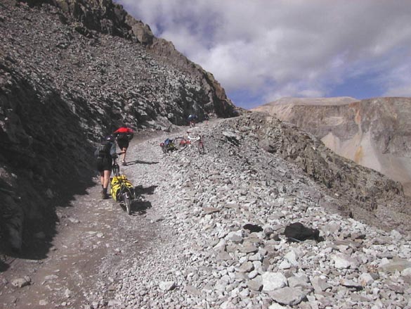
Suddenly the road broke out into an open valley and the grade became impossible to ride. A four wheeler went by and had to slip the clutch and rev his engine several times to make it up one incline. We pushed up the first pitch. On the second, steeper one we experimented a bit. I tried disconnecting my trailer and carrying it up like a backpack. Possible, but not fun. We then pushed Jeannes bike-trailer combination up together. That was much better. At least we now had a feasible way to get our rigs over the steeper climbs we knew were higher up on the pass.
After this first steep section, we were able to ride, with difficulty, most of the road up to Upper Camp Bird, a mining ghost town at the edge of tree line, where we stopped for lunch. Feeling good, we opted to continue up the switchbacks that stretched up the valley wall ahead. The road became progressively steeper and rougher, reducing our progress to a push and stop, one mile per hour rate, then even slower as we were forced to combine our efforts on one bike, then go back for the other on each steep incline. We crested the headwall of the valley, and were rewarded with a tantalizing view of the top of the pass, perhaps 1 mile and 500 feet above us. We also were concerned to see heavy dark clouds spilling over the pass in our direction.
As a light rain began to fall, we stopped for a quick snack and to discuss our situation. We had pushed ourselves really hard to reach this point and were definitely starting to slow down. We figured that it would take us at least an hour and perhaps more to drag our bikes up and over the top, with several sections requiring that we combine our efforts on one bike at a time. The clouds coming over the ridge were looking darker and darker, and it was impossible to tell if thunderheads were building above the lower clouds that we could see. We were well above tree line and there werent any sheltered places to pitch a tent that would have been safe during a thunderstorm. We both decided that we would feel really stupid if we pushed on in uncertain conditions and one of us got struck by lightning on top of the 13,000 foot high pass. Opting for safety over desire, we hopped onto the bikes and headed back down the way we had come, towards the trees. As we did so, it began to hail.
We stopped halfway down to tree line and inspected a small, fairly flat shelf of grass next to the road as a potential campsite. I felt it was a relatively safe spot from lightning, given the proximity of a high ridge on one side. After some consideration, we again opted to continue down. Almost immediately, a thunderstorm broke loose. We skidded and slid as fast as we could down the steep, wet, rock strewn switchbacks to tree line, with the B.O.B. trailers bouncing wildly behind.
At tree line, we hurriedly located a tent site. With hail pounding and bouncing around us and occasional strobe-like flashes and crashes of thunder to spur us on, we hastily assembled the tent, threw our drybags inside and jumped in. In no time, we were cozy, dry and warm, ensconced in sleeping bags and contentedly reading novels, as bursts of wind blown cold rain pelted the tent. Despite having missed getting over the pass and having to come back down 1000 feet of hard earned elevation, we felt very happy to be safe and dry in our tent rather than on top of a 13,000-foot high ridge in the storm. We had traveled only a total of 5.7 miles, with an elevation gain of 2000 feet, close to 1000 feet of which we had sacrificed in our retreat to tree line.
Late in the afternoon, the sun came out for awhile, and we opted to take advantage of the break to cook dinner outside while it was relatively nice out. As we were finishing a meal of pasta with garlic sauce, two mule deer does and two fawns stepped out from the trees 30 yards away. They initially bounded away upon seeing us, but curiosity won out over caution, and they returned for a better look. They seemed to be more comfortable if we continued to eat than when we looked directly at them, so we kept spooning dinner, pretending not to watch them as they ambled around the edge of the trees and out of site behind a few bushes. Meanwhile, two large white-tailed deer appeared about 40 yards below our tent site, and spooked, snorting, stomping and finally bounding away.
After dark, we baked coffeecake as a bright moon came up. A jeep descended the steep, wet switchbacks above us, headlights bouncing. Suddenly a long dark shape appeared, sticking out from a bush at ground level about 10 feet away. I turned my headlamp on hoping it wasnt a skunk, and the shape coalesced into the long neck of a deer, his head swiveling to look at us, eyes reflecting the headlamp. I shut the lamp off and the deer trotted away across the meadow. A couple of minutes later, we heard a noise to our right, and looked to see another deer, or perhaps the same one, sneaking stealthily through our campsite. Jeesh! Time to put up a "No Trespassing" sign!
We went to sleep hoping we would wake to clear, sunny skies for the push over the pass into Telluride.
Day Seven
On Friday, we woke to rain and high winds. I thought, "Maybe its just an early morning shower. Itll clear up." It started to snow, hail and thunder. The snow piled up on the tent causing the ceiling to creep lower and lower. I felt like we were Batman and Robin, trapped in a trash compactor. Periodically, we slapped at the tent walls to knock the snow off, giving us instant headroom for a few minutes.
During a break in the weather in the afternoon, the sun came out for awhile and melted most of the snow. We put our books down and amble outside wearing down parkas and rain gear. I wandered across a small drainage and sat under a tree while Jeanne sat out on a rock by the tent with her book.
It didnt take long before the wildlife became accustomed to us being out there, amazingly accustomed. First, a group of tiny gray bush tits flew from one tree to another, one following another at 1 or 2 second intervals until 30 or 40 birds had crossed the meadow. Growing bolder, they followed each other down into the meadow to feed, perching on flowers, talking back and forth in animated, high pitched chirps that bordered on the upper limits of our hearing. Soon they were joined by animated black capped mountain chickadees, yellow goldfinches, gray jays, stellar jays with their blue bodies and iridescent punk rock style feathered crests, and red headed finches, until the small meadow in front of where we were sitting was filled with birds.
As I sat motionless, leaning against the trunk of an Englemann spruce, birds began flying back and forth between the meadow and the tree I sat at. It sounds strange, but they seemed to be attracted to us, almost as if they were putting on a performance. I had birds perched all around me, in the tree and on the ground. They were chirping back and forth, and were in constant motion, flitting from branch to branch, zooming out to the meadow, back to the tree, down to the ground to peck at forest debris around my feet. As they flew to the tree, most of them would fly straight at me, veering up into the branches above my head at the very last instant. It was like being strafed by a miniature air force, except the whole thing had an atmosphere of fun to it, like they were glad for the opportunity to show off. Ive never experienced anything quite like it before, but would be happy to experience it again any time.
A family of coyotes broke into yips and quavering howls on the slope across the valley. The whole scene was definitely taking on an air of unreality. At that point, the deer began to show up again. A doe and a fawn walked into the meadow, stopped and look at me for a moment, then dropped their heads and browsed. Another large deer stalked curiously up in Jeannes direction, neck outstretched, ears swiveling nervously. A doe walked into the trees with a fawn and came back out leading two fawns. Two deer ambled along farther down the meadow. Several other deer, both does and fawns, approached Jeanne from the other side of the trees. A large bird perched on the tip of a tall plant in the meadow. The plant bent almost double under its weight and the bird went into comical contortions in a futile attempt to stay on his chosen roost. The wind sighed, cloud shadows drifted past, a small brook gurgled. Somewhere up on the cliffs above, a rock fell. Pikas squeaked from the talus slope just above us. A late summer hummingbird whirred past. It was a nature watching heaven! I tried very hard to remember why I should ever leave a place like this and return to working in the office. I completely failed.
Eventually, the sun disappeared behind the next wave of clouds, my stomach began to growl, and I stalked over to Jeanne, scaring away her share of the deer in the process. We ate a hot meal of minestrone soup and then baked a pineapple upside down cake for dessert. Both were absolutely delicious.
Later, we discussed our options for the remainder of the trip. I was of the opinion that the weather had taken a definite long-term turn for the worse. Even if we managed to get over the top of Imogene Pass in the morning, we would then be on the wrong side of the mountains with a long ride and another high pass (Ophir) to go over to get back to our car. I felt that there was a good chance we would end up weather bound in Telluride, and would end up needing to rent a car to drive back around to Silverton on Sunday to get our car and get back to Grand Junction in time for work on Monday. I opted that in the morning, we should ride back down the way we had come to the town of Ouray, and then ride the 25 miles of Highway 550 over 11,000 foot Red Mountain Pass from Ouray to Silverton. It would be better graded and a much easier and shorter ride than pushing over Imogene, down to Telluride, up to the town of Ophir, over Ophir Pass and down to Silverton. We both agreed that going back would be the wise thing to do, but not what we really wanted to do, at all.
We had heard that tomorrow the Ouray to Telluride Imogene Pass footrace would take place. That would be something to see.
Day Eight
We woke on Saturday to cold, windy weather, but the skies were clearing. As we breakfasted on granola with hot chocolate, we heard distant cheering. Minutes later, a figure in a bright green wind jacket jogged and speed walked his way up the jeep road towards the switchbacks heading up the headwall. Then several more followed, until a steady line of people formed a brightly colored line snaking up the road.
Jeanne was really gun ho on the idea of continuing over the pass to Telluride, and riding Ophir Pass. Despite my pessimism about the chances of getting good weather, I had to agree with her. Id much rather ride the off road route than the paved highway. We packed up and joined the line of racers huffing their way up the mountain.
The racers, who were were traveling 18 miles (they use a shortcut through Camp Bird Mine) from Ouray at 7700 feet, to Imogene Pass at 13,000 feet and down to Telluride at 9000 feet, were a very friendly and enthusiastic bunch of people. They gave us a lot of encouragement as they passed us, and occasionally helped us push our bikes up the steeper sections.
Jeanne pushing her bike up the Imogene Pass Road, with racers ahead of her
It made the two hours of huffing and puffing a lot more fun than it might have been otherwise, and we arrived at the summit before noon, where we were offered snacks and drinks by the race organizers.
Top of Imogene Pass, 13,000
As we descended the 8 mile, 4000-foot rocky downhill section into Telluride, we passed several of the racers who had passed us on the climb to the pass, and we cheered each other on. In Telluride, we stopped in to look at the Telluride Museum, a restored former miners hospital that I had designed the new heating system for, and then continued down to Baked in Telluride for bagels with humus for lunch. Jeanne also picked up a few bagels for Sundays breakfast. Then on to The Downstairs Deli for chocolate ice cream cones, which we enjoyed sitting out on the sidewalk in the warm sun. Jeanne watched the bikes and trailers while I looked unsuccessfully for nylon repair tape for our tent and fuel for the stove.
The sidewalk scene in Telluride was zoo-like, especially after spending yesterday in the wilderness. One scruffy guy walked by with a black labrador on a leash. The dog had a nylon saddle on. On the saddle stood a gray cat which was leashed to the dog. The cat bobbed confidently along as the dog trotted through the crowd. Another dog looked incredulously at the cat riding the dog and growled, as if he felt betrayed by another member of his species.
Jeanne watched as a shopkeeper came out of a store with two customers. They spread an expensive (Persian?) carpet on the sidewalk to get a better look at the colors in the natural lighting. As they gazed admiringly at the rug, a bicyclist rode right across the carpet. Suddenly realizing what he had just done, he squeaked, "Oops!" and looked back sheepishly before speeding away. The shopkeeper and customers hastily snatched the carpet up and disappeared into the store as Jeanne tried to control her laughter.
We stopped at the grocery store for dinner ingredients, and then headed for the gas station. Whipping out my trusty credit card from a zip lock baggy, I made the big purchase of the trip, 24 cents in unleaded gas for the stove. I did a quick mental calculation and came up with a satisfying 400 miles per gallon fuel consumption rate.

Gassing up in Telluride
At three in afternoon, we began the long climb on paved road 145 south from Telluride towards Ophir. The weather had turned incredibly nice. Blue skies, no clouds, Aspen trees beginning to turn bright yellow, the rich smells of the beginning of autumn. We pedaled along admiring the views of 14,017-foot high Mt. Wilson a few miles to the southwest. After a nice, high speed downhill, we turned east onto the unpaved Ophir Road, and pedaled uphill towards the old town. As we did so, we pedaled across the run out paths of several major avalanche chutes.
I stopped to take a picture of Jeanne riding up towards town, with the high peaks above, and fell into conversation with a man hiking along the road.
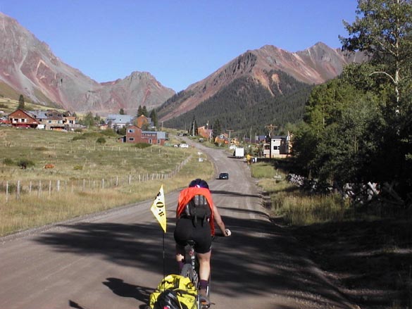
Jeanne heading into Ophir. Ophir Pass is in the notch above town
He had been renting a house in Ophir for the last few years and was now building a home in town. I asked him about avalanche problems in the winter, and he said that, yes, avalanches were a big concern there, but it was a great place to live. He talked about backcountry skiing from his back door on the slopes above town. I had to agree, it looked like a very nice place to live. Asked about camping, he responded by telling me about a side road a mile or so above town that led to a secluded meadow with a brook and great views in all directions. He commented that it was his favorite place to camp in the world. I thought that was an interesting thing, to live in such a nice spot that your favorite place to camp was only a mile from your home. People waved as we pedaled up the hill through town and onto the steeper road starting up Ophir Pass. The town hall looked like it had formerly been a miners house. The post office was a small shed by the road in front of a house. Interesting town.
After some trial and error, we located the side road to the meadow around 7:30 PM, and after splashing through a creek that ran down with the road for some distance, we arrived at the meadow, which was beautiful, as predicted by our friend in town. As Jeanne rested with the bikes, I scouted around for several minutes until I had found what I felt was the absolute best spot, with a view of the peaks in all directions. When I finally returned to Jeanne she was hopping up and down in tired frustration. With eight days of practice, we had the tent set up, the water bag filled from the stream, the stove heating dinner, and dry warmer clothes on in a matter of minutes. Soon we were eating a store-bought meal, pasta with olive oil and garlic herb sauce, and watching the sun set down the valley. We figured out that we had ridden about 25 miles, with a little over 3000 feet of climbing for the day.
As we cleaned up the dishes, a three quarter moon rose over the meadow. An unidentified night bird screeched periodically from an adjacent tree. Across the stream in the woods a bull elk bugled. I had never heard it before. It sounds more like a cross between a whistle and a scream. As the sound echoed off the valley walls, the bull was answered by a series of weird loud deep grunts and barks from the edge of the trees to the east. We later found out that these sounds were a female answering the male. To finish off the moonlit scene with the elk calls echoing in the frosty night air, a coyote joined in, its quavering Loon-like call echoing back and forth. We both agreed it was a magical place to spend the last night of the trip.

Meadow campsite above Ophir
Day Nine
We woke up to more perfect weather. The white gas stove hissed, as it burned the unleaded gasoline wed bought in Telluride. We fried bagels in butter on a teflon pan as we waited for the sun to dry the frost off of the tent.
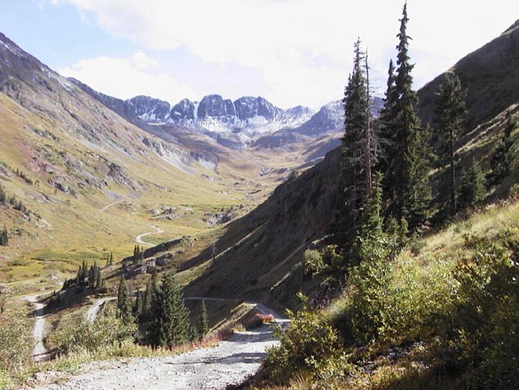
Savoring the last day of our trip, we pushed and rode slowly up a rocky jeep road, across a steep talus slope with wonderful views of Lizard Head Peak and Mount Wilson.

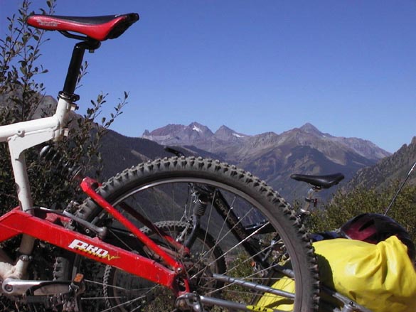
Ophir Pass Road above Mt. Wilson (above Lincs back wheel)
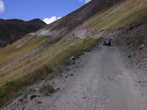
We swapped stories and information about where to eat in Telluride with three bikers riding the opposite way. They were riding the same loop as us, but in the opposite direction, and in four days versus our nine-day trip. To keep from having to carry gear, they were staying in B&Bs and eating breakfasts and dinners in the towns between passes. They had carried a camp stove, which they had needed to use to stave off hypothermia when crossing Engineer Pass in the rain and hail two days before. Thats the problem with doing the loop as a credit card ride. If you have bad weather, you tend to push yourself over the exposed summits at high risk to avoid losing out on your lodging reservations.
After a few miles we had climbed the 2000 from our meadow campsite to the summit of Ophir Pass, just short of 12,000 feet high. We stopped to talk with three guys who had driven up from the Silverton side to go fishing. One of them hoisted a partially inflated rubber kayak on his shoulders and started climbing the scree slope on one side of the pass. "Wheres he going with the boat up here?" I wondered aloud. "Theres a lake just over that summit, at about 12,500 feet. Great place to fish!" we were informed. "Wow", I thought, "now thats a pretty cool way to spend a nice late summer day, floating around in a clear alpine tarn high above tree line with your fishing rod."


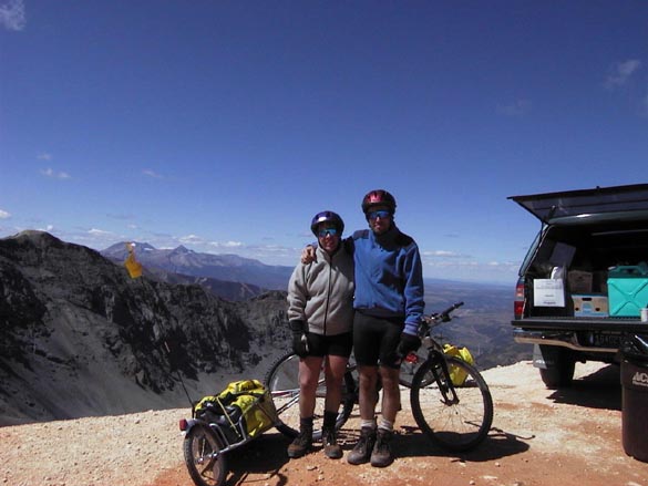
Jeanne crests Ophir Pass The handsome couple on Ophir, 9 days, one shower
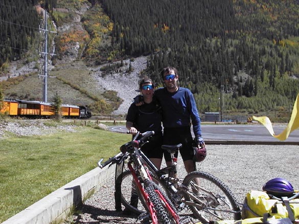
Back on the bikes, we cruised on down the jeep road, passing through glowing tunnels of Aspen, green and flaming gold leaves flashing past, interspersed with blue sky, then open views down valley. In no time, we were on Highway 550, coasting the last few miles of easy downhill to where our car waited at the Visitor Center in Silverton. We used up the last picture left on the digital cameras memory card to take a timer self portrait of our scruffy but happy selves, standing with the bikes, the Silverton-Durango coal fired tourist train puffing steam and smoke in the background.
Tired but happy!
Nine days, 129 miles, 17,400 feet of elevation gain, 83 photos, lots of memories to treasure, amazingly, all of them good. Wed do this trip again in a heartbeat.
The end.