|
Montauk Air Force Station
Historical Timeline
|

|
|
Photo: Donald E. Bender
1948
The Air Force deploys its first radar set, a World War Two vintage AN/TPS-1B, at
Camp Hero in June of this year.
The Montauk site is one of the first three early warning radar sites hastily established
in the northeastern United States
to provide an interim detection capability pending the creation of a more fully
developed radar network.
Radar data from the Montauk base is transmitted to a manual control
center located at Roslyn. The Montauk site becomes a component in the nation's first
radar network,
known as the "Lashup" system. It is designated as site "L-10" in this system.
1951
The site's original radar is replaced by an AN/CPS-5 surveillance radar which operates in
conjunction with an AN/TPS-10A height finder radar. Manned by the Air Force's
773rd Aircraft Control & Warning Squadron the base is a component of the nation's second
Cold War radar system, the "Permanent" radar network. It is designated as site "LP-45" within
this network.
1952
Two new radar sets are deployed at Montauk. The AN/FPS-3 is an improved version of the
AN/CPS-5. The second radar, an AN/FPS-5, is a new long range surveillance radar which
was produced in very
limited quantities.
1955-1956
An AN/FPS-8 medium range search radar is deployed at the site. This radar set is subsequently
upgraded and redesignated AN/GPS-3.
1957
The Montauk base is one of the first in the nation to receive the new AN/FPS-20 surveillance
radar. The new surveillance set becomes operational during the spring
of this year and is joined by two AN/FPS-6 long range height finder radars.
1958
The base is officially integrated into the nationwide Semi Automatic Ground Environment (SAGE)
air defense network. Radar data collected at the site is now supplied to the SAGE
Direction Center located at McGuire Air Force Base in New Jersey.
1960
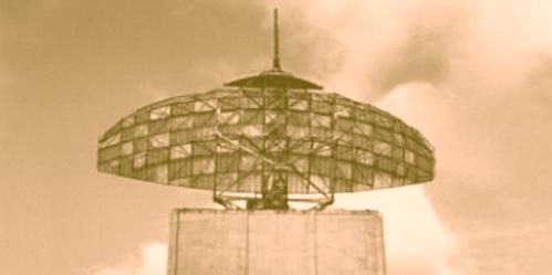
The AN/FPS-35 frequency diversity radar, the first production model of
this technologically advanced unit, is activated at the base during December. The
giant antenna of the radar measures over 120 feet in width and weighs approximately
70 tons.
The new radar provides a greatly enhanced capability against
hostile aircraft utilizing electronic countermeasures or "jamming" techniques which
could have interferred with the site's ability to track them.
1961
The AN/FPS-35 is quickly removed from full time service as it causes electrical interference
which affects local television and radio reception. Tests are conducted to adjust the system
to reduce the interference problem.
1962
The AN/FPS-35 is returned to full time service. It will serve as the site's surveillance
radar until its closure in the early Eighties.
1963
One of the site's two original height finder radars, an AN/FPS-6, is replaced by a more
advanced AN/FPS-26 which incorporates frequency diversity features.
During this same year, the Montauk installation becomes a joint FAA and Air Force site.
Radar data is used by the FAA for air traffic control and by the Air Force for air
defense operations.
Under a nationwide plan to rename radar sites within the SAGE air defense
network, existing sites are redesignated by the letter "Z". The Montauk Air Force
Station is subsequently known as site "Z-45".
The 773rd Aircraft Control & Warning Squadron becomes the 773rd Radar
Squadron (SAGE).
1965
The joint use of the site by the FAA and Air Force ceases. The Montauk base reverts to its
original mission of providing air defense radar coverage for the region.
1967
The SAGE Direction Center at McGuire Air Force Base, New Jersey is inactivated. Radar data
from the Montauk base is subsequently transmitted to the SAGE Direction Center at
Hancock Field, New York.
1979
Aerospace Defense Command (ADCOM), the successor organization to Air Defense Command,
is absorbed into the Air Force's Tactical Air Command (TAC).
Operation of the base is transferred to Tactical Air Command.
1980
A new FAA operated radar site is activated near Riverhead, Long Island. The new site
contains an ARSR-3 Air Route Surveillance Radar as well as an Air Force owned AN/FPS-116
height finder. The new site becomes operational in late 1980.
1981
The 773rd Radar Squadron is deactivated. All radars at the Montauk base are removed
from service by the end of January. The GATR (Ground Air Transmitter Receiver)
facility located atop nearby Prospect Hill remains in service to
direct fighter-intereceptor aircraft operating within the region.
Radar coverage of the region for both military air defense and civil air traffic
control purposes is provided by the new FAA operated radar site near Riverhead.
1984
The GATR site is shut down following the deactivation of the
SAGE network and its subsequent replacement by the
Joint Surveillance System (JSS).
1997
Circa 1997, the FAA operated ARSR-3 radar at the Riverhead site is replaced by a long range
radar of more advanced design. The new ARSR-4 Air Route Surveillance Radar is a
"three-dimensional" set which provides information regarding the direction,
distance and height of airborne objects within its area of coverage.
|
| � � |
|
SITE CURATOR: DONALD E. BENDER
E-Mail: [email protected]
|