The Avebury Complex
Avebury, Silbury Hill and Stone Henge
Avebury
The huge henge monument at Avebury alone covers
almost 30 acres and is itself surrounded
by dozens of other Stone Age ritual sites, the most important being Silbury
Hill the largest
manmade mound in Western Europe. Avebury encircles a medieval village with
its parish church
of the 'new religion' standing just outside the ring of giant stones. The
1,400ft diameter bank is
25ft high on its outer aspect, the inner, when measured from the bottom
of the ditch (now
silted up) is 33ft deep. It is telling that these so-called barbaric and
warlike tribesmen could
unite and be motivated to dig 10,000 tons of chalk with nothing but antler
picks! The ditch
itself, situated on the inside of the bank, demonstrates that it did not
have a defensive function
but may have been built as a 'grandstand' for observers of the rituals
taking place inside the
henge. Today's visitors follow the path taken by pilgrims who, more than
4000 years ago came
to take part in their religious assemblies and festivals. The festivals
probably evolved into the
Celtic quarter days.
Experts agree that the henge and circles date from
between 2600 and 1600 BC. In it's heyday
the monument would have been a stunning sight, its banks and ditch of exposed
chalk dazzling white. There were four entrances to the henge cut through
the bank and ditch, around the circumference was a circle of 100 gigantic
sarsen stones, some weighing as much as 40 tons.
They were all dragged to the site from the downlands to the east of Avebury.
Only 31 of these
stones still remain. Inside the circle were two smaller rings, each over
300ft in diameter. The
north circle contained a 'cove' made up of three stones facing northeast,
while the south featured
the tallest standing stone, the Obelisk, which seems to have been the ceremonial
central point
of the henge. Stukeley sketched the fallen obelisk shortly before it was
destroyed for building
material in the eighteenth century. Its importance may have survived in
folk tradition for villagers
still danced around a maypole set up on the south circle one hundred years
later. Were isolated
or central stones perhaps the forerunners of the Maypole? Maybe dancing
round the Maypole is
a ritual that goes back farther than is presumed?
A lot of the assistance has been given with regards
to the sites earlier appearance by the seventeenth and eighteenth century
antiquarians who 'discovered' the site. The first was John
Aubrey the latter William Stukeley, who watched helplessly as local people
destroyed the stones
for use in local buildings while he was still drawing up the plans of the
sites remains. The destruction of the temple had been going on, intermittently,
for some time it seems to have begun
in the fourteenth century. There is no record of a church at Avebury in
the Domesday Book, which would imply Christianity was not practiced in
the area until 1085 at the very earliest. Christian
priests or missionaries settling in the village may have been alarmed by
the continuing hold paganism had over the area and ordered the monument
dismantled. Dozens of stones in the inner and outer circles were toppled
and buried in chalk cut-pits, others were broken into pieces. Fortunately
this process seemed to come to an abrupt end when a thirteen-ton sarsen
fell upon a barber surgeon as he was helping to move it, crushing him to
death. His skeleton was found in
1938 when a team, lead by Alexander Keiler, were moving the stone to replaced
in its original position near the south entrance of the henge. The barber
surgeon's accident coupled with the
arrival of the Black Death in 1349 could well have suggested to the villagers
that it was perhaps
not such a good idea to 'mess with the monument' because for the time being
all further
destruction of the stones was halted.
Keiler's phenomenal work at Avebury during the
1930's resulted in the restoration of much of the site. Buried stones,
which were dug up with a great deal of effort were re-erected and where
evidence of destroyed stones was found, small concrete markers were put
in their place.
Beginning at the south entrance of the henge begins
is the avenue of standing stones known as West Kennet Avenue. This may
have been the processional route for those taking part in the
rituals at the henge. Originally it consisted of near 100 individual pairs
of slender upright pillars facing diamond shaped companion stones. It has
been suggested that these shapes in their arrangement were symbolically
male and female. Only twenty-seven stones remain, with
thirty-seven concrete posts marking absent friends. It has been thought
there could have been a second avenue from the eastern entrance into the
henge. Stukeley recorded stones here, but so
far no traces of their existence has been found, all that is seen today
are two large standing
stones known as Adam and Eve. The West Kennet Avenue runs one-and-a-half
miles to a site
known as the Sanctuary on Overton Hill near the river Kennet. Although
little remains, we know
it once consisted of two rings of stone and six concentric timber rings
which are the remains of
a large wooden roundhouse. Evidence of feasting and mortuary rituals have
been found, but the structure's function remains a mystery.
Findings suggest Windmill Hill to be the oldest
site in the complex, it is a mile northwest of the main Avebury complex.
The hilltop was settled very early in the Neolithic period and seems to
have functioned as a meeting place or 'fairground' for over a thousand
years. The hill is circled
by the ditches of a causeway camp which dates back to 3400 BC and remains
of animals and humans, including skulls have been found in them.
Another feature of the site is the many clusters
of barrows on the hillsides above Avebury and
the River Kennet. The most impressive and well known is the West Kennet
Long Barrow, and is similar in age to Windmill Hill. West Kennet at 330ft
long is one of the largest barrows of its
kind in England, it is orientated east-west with a façade of huge
stones blocking the eastern end. When excavated, the five side chambers
inside were found to contain the disarticulated remains
of around 50 people, it seemed to have been used for ritualistic purposes
over a long period of
time. Of the skeletons found there was a marked lack of skulls and long
bones - these may have been moved and taken elsewhere for ritual, perhaps
to Windmill Hill, which could explain the presence of the skulls, found
there.
Silbury Hill
Looking towards the west from the West Kennet Long
Barrow an impressive view of Silbury Hill
can be seen nestling in the lowest part of the Kennet valley below with
the ridge of Waden's Hill, (the hill of the god Woden), rising up behind
it. Silbury appears to have been the real focal point
of the entire Avebury complex. It is a unique and phenomenal piece of prehistoric
landscaping, a gigantic, 130ft high, manmade mound built using nothing
but bare hands and antlers fashioned
into picks. It was the product of community effort, pieced together over
a period of 50 years from blocks of chalk covered with turf, built the
same time as Avebury Henge. Maybe it was the
crowning achievement of the Pagan priests who planned Avebury.
For centuries it was believed Silbury was the burial
mound of a rich king or warrior. Folklore told
of a man buried on horseback or in a golden coffin. The mound was not a
burial site, In the
1960's the BBC sponsored a tunnel to be dug deep into the heart of the
mound, no evidence of
any grave was found. What was discovered were the original turves used
in the construction of the
hill in the Stone Age, the grass and insects miraculously preserved inside!
Analyses showed they
were cut at the beginning of the harvest, perhaps early in August at the
time of the festival of Lughnasa.
Archeologists have never been able to fully explain
why Silbury Hill was built with its huge investment in time and labour.
There have been some well-researched and educated theories
though. Earth Mysteries experts like artist and author Michael Dames, believes
Silbury was a
great 'harvest hill'. Harvest hills were early versions of the Lammas Towers
that were built within living memory, at Lughnasa in Ireland and Scotland.
He theorises that the sacred mound was
built to represent the abstract image of the Neolithic Earth Mother or
fertility goddess who was
visualized as a squatting figure in the landscape giving birth. Dames had
traced the form of the goddess in the landscape around Avebury, with natural
and manmade features marking the figure itself. His theory is enhanced
by the presence below the hill of a spring, one of the sources of
the River Kennet, which had healing powers. He further compared the "Sil"
element of Silbury,
with Sul, the name of the Celtic goddess who presides over the healing
springs of bath. Sul or
Sulis was also an eye goddess, linked with the sun.
Silbury was still an important ritual gathering
place for villagers until well into the eighteenth
century when Stukeley wrote of a Palm Sunday feast held every year on the
top of the hill.
Another account from 1736 describes a race around the base of the hill
followed by wrestling
and dancing which ended with a bull being baited on the summit, killed
and roasted whole. All
these customs suggest the hill was associated with ritual activity over
a long period of time.
Recently Paul Devereux has taken Dame's ideas and
expanded on them using evidence from archaeology and personal intuition.
He has made some fascinating insights into the function of
Silbury and its relationship with Avebury and the surrounding ritual landscape.
Devereux made observations from each of the sites over many years, at different
calendar dates, and with the
help of 'inspiration' the secrets of the landscape were revealed. They
involved subtle visual connections, including harvest dependant sight lines,
between Silbury and it's surrounding barrows
and stone circles. The most spectacular of these is observed from the terrace
of Silbury Hill, a
unique 'double sunrise' effect occurring on two important festivals in
the pagan calendar, the beginning of May at Beltain (sowing of crops) and
Lughnasa in early August (the harvest).
This kind of subtle interaction between astronomy,
earth and horizon has been found at other megalithic sites and shows that
geometry and landscape sculpture on a vast scale was created
and utilized by the prehistoric priests.
Stone Henge
Stonehenge was referred to in 1135 by the chronicler
Geoffrey of Monmouth who claimed it was brought by a tribe of giants from
Africa to Ireland, and from there flown by Merlin across the sea. Another
legend tells of the stones being stolen from an Irish woman by the Devil,
and re-erected
on Salisbury Plain by Merlin for Ambrosius Aurelianus, the King of Britons.
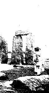
This is certainly the best known of all megalithic
sites, its standing stones and design recognized
the world over. Stonehenge stands alone on the undulating chalk of Salisbury
Plain, a monument
to early man. When viewed from a distance the site gives the impression
of being a relatively
small construction, this is an illusion given by the sheer size of the
stones. The tallest upright
stone is 22ft high with another 8ft buried below the ground.
Beginning at the entrance to the earthwork enclosure
is the Avenue, it runs down a gentle slope
for 560yds into Stonehenge Bottom. The Avenue consists of twin banks approximately
40ft apart
and has internal ditches. At the far end can be found the Heel Stone, a
large upright unworked sarsen, hard sandstone, lying immediately next to
the A344 road. These huge stones were
brought from the Marlborough Downs18 miles to the northeast, the nearest
source of stones with
the dimensions of the sarsens at Stonehenge. There is no conclusive evidence
how the stones, weighing up to 45 tons, were transported over this distance
but one theory is that some type of sledge was used or they were rolled
forwards on logs. As you move towards the monument from
the Heel Stone, you come to an earthwork enclosure consisting of a ditch
and interior bank.
Professor Atkinson calculated the height as 6ft. There were originally
at least two entrances, one
still visible to the NE and one to the south, blocked by a fallen unworked
sarsen stone. This was named the Slaughter Stone due to being stained a
rusty red. This was not caused by sacrificial
blood soaking into the stone but by rainwater causing the iron in it to
rust. Originally, around the inner aspect of the earthwork bank were four
small upright stones, the Station Stones, two are still
in situ. Adjacent to the bank is a ring of 56 pits called the Aubrey Holes.
There are at least two other sets of these holes to be found between the
inner edge of the bank and the outermost stone settings. These were imaginatively
named the Y and Z holes.
In the central area is the familiar stone structure
that sets Stone Henge apart from any other monolithic site yet found. It
is constructed from two types of stone, sarsen and bluestone. The
sarsens used in the centre are the largest on the site and from the same
source as the other
sarsen stones. The bluestone, however, are not local, they are rocks found
on the Preseli Mountains
in SE Wales. The most widely accepted theory as to how bronze age man managed
to transport
the bluestones from Wales to the Salisbury Plain was through sheer human
effort, partially by
floating the rocks along the Bristol Channel on rafts to the RIver Avon
at Bristol. Mystery
surround what is so special about these stones to justify such enormous
expenditure of energy
and time in their movement. Geoffrey Ashe wrote "For some reason the
Presli area was sacred,
and stones from there embodied a vital magic." It seems they were
rega rded as having healing powers, this may be connected to some magnetic
anomaly specific to the location from where
they originated, as recent research by Paul Devereux appears to indicate.
When Stone Henge was complete, the central outer
stones consisted of a circle of 30 upright sarsens, 17 of which still stand,
each weighing approximately 25 tons. The upright stones were
linked across the top by a continuous ring of horizontal sarsen lintels,
only a few of which are still
in position. The stones in the sarsen circle are shaped with the horizontal
lintels joined together using not only simple tenon and mortise joints,
but also a primitive type of dovetail joint. The
edges are smoothed into a gentle curve, which follows the line of the entire
circle. The bluestone configuration is concentric with the outer sarsen
circle, consisted originally of about 60 stones.
Many have fallen, disintegrated or been crushed. The two circles surround
the sarsen horseshoe, which originally consisted of five sarsen trilithons
(Greek for 'three stones'), each trilithon was consisted of two uprights
and a horizontal lintel. Although now fragmentary, the arrangement still
shows the five trilithons were graded, the tallest reaching 22ft above
ground level. Inside this
massive horseshoe, is a smaller one made from the bluestones.
Current archaeological research has shown that the site was constructed and modified in various phases, spanning several centuries and are as follows:-
Pre-Stonehenge (9th-8th millennium BC): at least
4 mesolithic pits originally containing pine
posts, in alignment approximately 250yds from the present henge site.
Stonehenge 1 (from 3100 BC): construction of the
circular bank, the ditch and the 56 Aubrey
Holes which probably originally contained timber posts.
Stonehenge 2 (from 2550 BC): pottery, animal bones
and cremated human remains were found
from this period placed in ditch. Also found ashes in some of the partially
filled Aubrey Holes
were the remains of cremations. There was a complex structure of posts
in the interior and in entrance causeway.
Stonehenge 3 (from 2100 BC): There was a sequence
of stone-related structures during this
time. Exact dating is unknown at present the sequence is presumed to be
the following
1.Bluestones from Wales erected in q and r holes and then dismantled
2.Sarsen circle and trilithons erected. A bluestone ring including trilithons
may also have been erected and latter dismantled.
3.Bluestone circle and oval layout.
4.A section of the bluestones removed from the oval leaving the present
horseshoe shape. 5.Construction of the Avenue and the Y and Z holes dug
These were possibly for stones, which
were never put in place.