
Maps on Himalayan Trekking Routes
The Himalaya has attracted geologists, geographer and lovers of nature. They have a strange fascination for artists, poets, photographers and mystics. They are a paradise for trekkers and mountaineers and are the cradle of thousands of rivers, streams and glaciers.
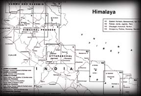
The Himalaya extends over 2500 km in east-west and between 250 km and 425 km in north-south direction. The most extraordinary thing about the Himalaya is the way they have been formed in three parallel ranges, known as; The Great Himalaya, the Lesser or Central Himalaya and the Outer or Siwalik Himalaya. Commencing at Nanga Parbat in the north-west, these ranges pass through Pakistan, Jammu & Kashmir, Himachal Pradesh, Garhwal, Kumaon, Nepal, Sikkim, Bhutan and Arunachal Pradesh.

We presents Leomann Maps of these areas on 10 sheets with short description on trekking routes, peaks and physical topography
 Cost : Rs.750 each sheet ORDER NOW
Sheet 1: JAMMU & KASHMIR
Cost : Rs.750 each sheet ORDER NOW
Sheet 1: JAMMU & KASHMIR
Srinagar, Kolohoi Glacier & Kishtwar area
Sheet 2: JAMMU & KASHMIR
Kargil, Zanskar & Nun- Kun area
Sheet 3: JAMMU & KASHMIR
Nubra Valley, Leh, Markha, & Zanskar area
Sheet 4: HIMACHAL PARDESH
Nubra Valley, Leh, Markha, & Zanskar area
Sheet 5: HIMACHAL PARDESH
Kullu Valley, Parbati Valley & Central Lahaul
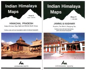
Sheet 6: HIMACHAL PARDESH
Kalpa - Kinnaur, Spiti & Shimla area
Sheet 7: UTTARANCHAL (Garhwal)
Gangotri, Har Ki Dun & Mussourie area
Sheet 8: UTTARANCHAL (Kumaon)
Pindari Glacier, Badrinath & Nanda Devi area
Sheet 9: JAMMU & KASHMIR / CHINA
Rupshu, Tso Moriri, Pangong Tso
Sheet 1: NEPAL HIMALAYA MAPS
Mansarovar, West Nepal, Api-Nampa, Seti river (Tibet)
East Kumaon, Panch Chuli, Darma/ Dhauli valley (India)
Recommend this site to A Friend!

