
Holderness, The fastest eroding coastline in Europe
There rolls the deep where grew the tree.
O earth, what changes hast thou seen
There where the long street roars hath been
the stillness of the central sea.
from a print in Sheppard (1912)

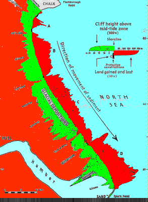
The Holderness coast is a 61 km long stretch of low glacial drift cliffs 3m to 35m in height. They sweep in a smooth S shape from just south of Bridlington in the north to Spurn Point in the south. This smooth shape is only broken where sea defences have reduced erosion at the protected point and increaced it southwards. Contemporary evidence of rapid erosion is abundant. Military pillboxes built in 1940-41 lie at the cliff foot, roads end pricipitously at the cliff edge and the local press regularly covers stories of properties falling into the sea.
Historical evidence is also abundant. Erosion has been rapid from at least the Roman era and dozens of villages and towns now lost to the sea are recorded.

The coastline of Holderness is eroding at around 2m per year. The erosion occurs mainly during storms and tidal surges and a loss of 6m was recorded over two days at Barmston in October 1967. It is estimated that about 76,450,00 cubic metres of material have been lost from the Holderness coast in 100 years (Valentin, 1954) . Only 3% of this material is deposited at Spurn Point, the remainder is deposited in deeper water offshore or is carried across the mouth of the Humber to be deposited within the estuary itself or on the North Linconshire coast. Erosion increaces as one moves southward.
The town of Bridlington at the northern extreme is protected by Flamborough Head to the north and the Smithic Sandbank which lies just offshore; this sandbank is 10 km long and at spring low water rises 2.7.m from the sea. South of this the 5 and 10 fathom (approx 10 and 20 meters) submarine contours lie close to the shore and there is no shelter from the maximum fetch across the north sea from the north east.
The cliffs are made up of loosly consolidated glacial till but there is no relationship between rates of erosion and type of till, nor with the height of the cliff.
From Valentin 1958
There are several factors resulting in the Holderness coast suffering such rapid erosion. The first is that the Holderness plain is a former bay infilled with easily eroded glacial tills. Waves undercutting the cliff produce slumping type landslips and the debris from these is easily swept away by the sea. A paleo-cliff runs from Sewerby on the south side of Flamborough Head to Hessle in the south and the sea is rapidly, in geological terms, cutting back to this pre-glacial shoreline.
R.G. Allinson-Winn (1904) showed that deep sea erosion was occuring as well as
cliff line erosion since the deep water has advanced over the sites of former cliff
line villiages. The submarine contours drop off rapidly offshore, at Dimlington
High land in the south the 10m submarine contour is only 600m from the beach.
The coast is thus subject to the full force of the waves from the north sea with
little attenuation before they reach the cliffline.
The chalk headland of
Flamborough Head
prevents transport of materials from the north by the dominant north easterly waves.
The resistant upper chalk, with very little flint produces a beach of rounded
pebbles at Sewerby.These are easily destroyeed by mechanical and solutional action
and decrease very rapidly in quantity southward.
The result that little beach material is transported southward to the beaches of
Holderness. The sea attempts to build up an equilibrium gradient by eroding the
soft cliffs behind the beach, to which the strong waves have easy access.
Return to Yorkshire Geology and Geomorphology homepage