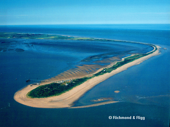
The photo shows Spurn Point from the south. The buildings in the foreground are a lifeboat station and Humber Pilots base. These are soon to be abandoned due to the likelyhood of the neck of the spit being breached. To the right deposition inside the curve of the spit (Old Den) can be seen. Just to the northwest of the lighthouse seen in the centre of the picture, but not visible in this photo are the old lighthouse keepers buildings, now derilict and partly overwhelmed by sand. These buildings were partly destroyed by winter storms a few years ago. The frequently relaid road to the tip is testament to the rapid movement of the spit neck.
Spurn Point is a narrow sandy promentory aproximately five kilometers long. It is located on the south-eastern tip of the Holderness plain which forms the northern banks of the Humber estuary. It is easily reached from Hull by car, parking is availible for which a small fee is payable.
The strategic position of the sand spit, guarding the entrance to a major waterway lead to its use as a position for shipping beacons and lighthouses. Historical accounts of settlements and lighthouses, particularly accounts of their destruction and the break up of the spit have enabled us to discover that over the last 1000 years there have been five 'Spurn points'. Each spit has grown until it has become unstable, been destroyed and then rebuilt slightly to the west of the former one, the cycles lasting approximately 250 years. The current spit is nearing the end of the cycle, and despite considerable coastal defences the neck is in continual danger of being breached.
To the east lies the North Sea. The direction of maximum fetch is from the north-east and longshore drift is southward. To the north west is the low plain of Holderness. This is composed entirely of glacial till filling a former embayment. (see the paleo-cliff at Sewerby The glacial till cliffs of Holderness are rapidly eroding.

Note the proximity of the farm to the cliffs, such buildings are frequently falling into the sea! The coast is eroding at between one and two metres per year and this erosion is intimately linked with the morphology of Spurn Point. The reasons for the rapid erosion of this coastline are dealt with in The Holderness Coast _Rapid erosion
In the initial stage of its formation spurn point begins as a sandy promentory which grows southwards then begins to curve westwards. As deposition occurs the spit elongates and sand passing around the tip causes the tip to elongate. Thus far we have a fairly standard spit formation mechanism. What makes Spurn Point interesting from a geomorphological perspective is the cyclical nature of the feature. This is due to the dual processes of spit formation and rapid coastal erosion. The spit grows southwestwards, at the same time the neck of the spit must move westwards due to the erosion of the coastline. Eventually a landform similar to the current situation evolves with an attenuated neck and a bulbous tip. A point is reached where the neck becomes vunerable to destruction by north-easterly gales and when the neck is breached swatchways develop and the spit is rapidly destroyed. Once this has happened the stage is set for the cycle to begin again, a little to the northwest of the former spit.
REFERENCES: Boer, G De. (1964) Spurn Head: its history and evolution. Trans. Inst. Brit. Geogr. 34, 71-89