 |
|
 |
|
|
|
|
|
|
|
|
|
|
|
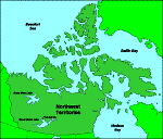
| Capital | Yellowknife |
| Motto | None |
| Flower | Mountain avens |
| Largest Urban Centres | Yellowknife, Inuvik, Hay River, Iqualuit, Fort Smith, Rankin Inlet |
| Population | 53,000 (1986c); rank: eleventh; .021% of Canada; 46.3% urban |
| Languages | 53.6% English; 2.5% French; 27.8% Inukitut; 16.1% other |
| Entered Confederation | July 15, 1870 |
| Government | Territorial - Commissioner, Executive Council, Legislative Assembly
Federal - 1 senators, 2 members of the House of Commons |
| Area | 3,379,684 sq. km. |
| Provincial Sales Tax | None |
|
|
|
|
|
|
|
|
|
|
|
|
|
|
|
|
|
|
|
|
|
|
|
|
|
|
|
|
|
|
|
|