
 |
  |
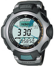
 [Code S-440] Rs.13,000/- + Rs.200/-Courier Charges  
 |
Full auto EL light, afterglow Measuring range: -700 to 10,000 m (-2,300 to 32,800 ft) Measuring unit: 5 m (20 ft.) Auto memory measurements (up to 40 records, each including altitude, month, date, time) High Altitude / Low Altitude Memory Cumulative Ascent / Descent Memory Relative Altitude Display Altitude Tendency Graph Altitude Differential Graphic Altitude alarm *Changeover between meters (m) and feet (ft) Measures and displays direction as one of 16 points Measuring range: 0� to 359� Measuring unit: 1� 20 seconds continuous measurement Graphic direction pointer Bidirectional calibration and northerly calibration function Display range: 260 to 1,100 hPa (7.65 to 32.45 inHg) Display unit: 1 hPa (0.05 inHg) Atmospheric pressure tendency graph Atmospheric pressure differential graphic *Changeover between hPa and inHg Display range: -10 to 60 �C (14 to 140 �F) Display unit: 0.1 �C (0.2 �F) *Changeover between Celsius (�C) and Fahrenheit (�F) Measuring capacity: 9:59'59.99' Measuring modes: Elapsed time, split time, 1st-2nd place times Measuring unit: 1 second Countdown range: 60 minute Countdown start time setting range: 1 to 60 minutes (1-minute increments) Others: Auto-repeat, progress beeper 57.0 X 52.0 X 14.8 mm / 77 g |
[GPS]
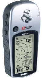
eTrex VISTA eTrex VISTA C About GPS GPS satellites circle the earth twice a day in a very precise orbit and transmit signal information to earth. GPS receivers take this information and use triangulation to calculate the user's exact location. Essentially, the GPS receiver compares the time a signal was transmitted by a satellite with the time it was received. The time difference tells the GPS receiver how far away the satellite is. Now, with distance measurements from a few more satellites, the receiver can determine the user's position and display it on the unit's electronic map.
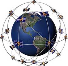 A GPS receiver must be locked on to the signal of at least three satellites to calculate a 2D position (latitude and longitude) and track movement. With four or more satellites in view, the receiver can determine the user's 3D position (latitude, longitude and altitude). Once the user's position has been determined, the GPS unit can calculate other information, such as speed, bearing, track, trip distance, distance to destination, sunrise and sunset time and more. Today's GPS receivers are extremely accurate, thanks to their parallel multi-channel design. Garmin's 12 parallel channel receivers are quick to lock onto satellites when first turned on and they maintain strong locks, even in dense foliage or urban settings with tall buildings. Certain atmospheric factors and other sources of error can affect the accuracy of GPS receivers. Garmin� GPS receivers are accurate to within 15 meters on average. 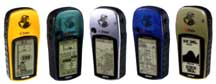
|
The eTrex Vista combines a basemap, with a barometric altimeter and electronic compass. The compass provides bearing information while you're standing still and the altimeter determines your precise altitude. The Vista is also designed to provide precise GPS positioning using correction data obtained from the Wide Area Augmentation System (WAAS). This product will provide position accuracy to less than three meters when receiving WAAS corrections.
Specification: [ Coloured Display ] 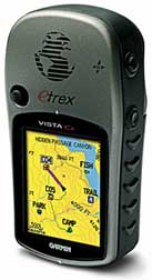 The eTrex Vista Cx is pocket-sized handheld that brings color features make it a mainstay among outdoor enthusiasts. You won�t miss a thing when you take this rugged, lightweight, easy-to-use handheld out trekking, hiking, biking, boating or even geocaching. |

