East Yorkshire Coast - Geology and Geomorphology
Before proceeding further please read this CAUTIONARY TALE
While virtual field trips present few dangers please take appropriate safety measures on real trips and follow the Geological Society code of practice.
Everyone can do geology!
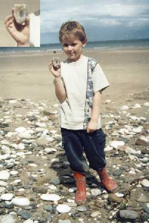
Short necked Plesiosaur or Pliosaur vertebrea found at Speeton by a youg member of York Geology club.
For the purposes of this page I have included the stretch of coast from the river Tees in the north to the river Humber in the south. Strictly speaking the Yorkshire border is at Staithes, a few kilometers south of the river Tees and thus a small part of Cleveland has been annexed. The river Tees however is the northern boundary of the lower Jurassic (liassic) outcrops and thus a more "geological" boundary than the county boundary.
In the north the cliffs at Boultby rise to 203m, the highest in Britain though much altered by alum quarrying. Southward the cliffs continue with magnificent 'solid' sections. (see photo above.) From Speeton to Bridlington the chalk forms a magnificent line of cliffs, the highest chalk cliffs in Britain. The headland at Flamborough has magnificent scenery of stacks and sea caves. South of Bridlington the low glacial till cliffs of Holderness sweep smoothly to the mouth of the Humber, guarded by Spurn Point
NEW An introduction to the Geology of East Yorkshire A geological guide to the coastal hinterland by Mike Horne F.G.S. the secretary of the Hull Geological Societywith a guide to local sites of geological interest, stratigraphy and a guide to geological fieldwork.
Coastal Landforms
The Yorkshire coast displays a number of coastal landform types. These include
high cliffs, bays, beaches and pocket beaches, shore platforms
headlands
, stacks and sea caves, rapidly eroding sections and an interesting
cyclic spit
formation
The Yorkshire coast displays some of the finest jurassic and cretaceous sections in Britain.
"The beds are deposited one upon the other just as one might pile some volumes of books; and there is a gradual dip or slope to the south-east, which enables one to walk along the cliffs and examine each bed in its proper order as it presents its surface in the cliff line. So admirable is this arrangement that it might be said that the sections have been arranged for the convenience of the geologist."
Sheppard, Thomas. (1906) "The making of the East Yorkshire Landscape."
South of Filey the low cliffs of Speeton show a non-sequence at the top of the Kimmerigian and the Portland and Purbeck rocks of southern England are missing. The Speeton clays form "the finest marine cretaceous in Britain" (Neal J. & Catt, J.)
Just south of Speeton Beck the chalk begins, with a layer of red chalk. The Chalk cliffs rise magnificent and precipitously to the highest chalk cliffs in Britain at Bempton (external link)The chalk headland of Flamborough show interesting crush and distortion features associated with the Howardian Fault Belt, thought to be a continuation of the Craven Fault system of the Yorkshire Dales.
At depth the Market Weighton Block, a bouyant and rigid structural block runs east-west from just south of Bridlington to just north of Hull. This exerted considerable influence on sedimentation throughout the jurassic and cretaceous forming a barrier to sediment spread from the north
South of Bridlington the 60 Km. long sweep of the Holderness coast is a rapidly eroding section of low glacial till cliffs containing many erratics from as far away as Scandinavia.
Fossils
Can you help identify this unusual ammonite
The Yorkshire coast is famous for its Jurassic and Marine Cretaceous fossils. These pages are more concerned with structure and landform but here is one of my favorite fossils
See the fastest eroding coast in Europe
Visit one of Yorkshires premier seaside resorts and see how its geology
influenced the development of the town.
Walk in the footsteps of a Jurassic dinosaur
Walk a kilometer and a half out to sea on a reef of Jurassic limestone
Stacks, seacaves and the highest chalk cliffs in Britain
Jet, alum and ironstone link the geology and the economy of the coast
If these whet your appetite why not see what field trips and lectures the
Hull Geological Society is running in the real world!
And why not visit some Geology related links
Everything you could want to know about the ongoing battle with creationists at
The
University of Ediacara University I would most like a professorial chair from.
A geologists
lifetime field trip list the inspiration to put this site up.
Basic Coastal processes tutorial a bit slow and basic but good if you want the basics
A whole chapter from a textbook on the coastal geology and geomorphology of Novia Scotia Beautifully produced but you need Adobe Acrobat to view it!
See a sea stack disappear
See the devastating effects of
Hurricanes and el-nino weather on the U.S. coastline.
A comprehensive and well crafted site about the gelolgy and geomorphology of
New York bight from City University New York.
I welcome comments, corrections and suggestions so why not Email me here
Start your field trip
Humberside Geologist Online
The University's Centre for Lifelong Learning runs a series of part-time geology course.
Geolectica.com Site of Geochallenge,
a fun and very hard geological puzzle.
This page has been visited
times.