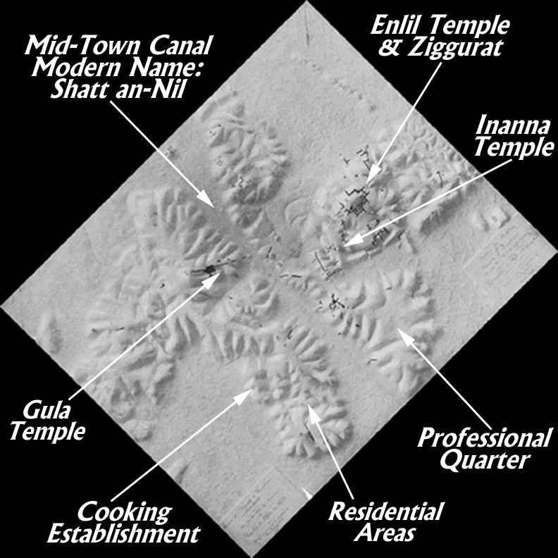
A photograph of this relief map is shown here with several significant features marked by arrows. Cursor down below for an explanation of these features.
A prominent feature of the layout of ancient Nippur was the Midtown Canal which flowed through the middle of the city. This may have been the original course of the Euphrates at Nippur, but when Nippur was resettled after the middle of the second millennium, B.C., it was designated as the Midtown Canal. This was a substantial watercourse, being more than 50 meters (164 feet) across in places. Another branch of the Euphrates River flowed around the western side of town. The deep trough marking the original bed of the Midtown Canal is now called the Shatt an-Nil. The two waterways were very valuable for transportation purposes. The storehouses of the major temples on the city's east side were quite close to the bank of the Midtown Canal. Pilgrims and donations could easily make their way into the temples through the strategically located Canal. From the two branches of the River, critically needed water for agricultural purposes could be led by a complex irrigation canal system out to the grain fields and date orchards.
The Midtown Canal divided Nippur into clearly-defined eastern and western sectors. The largest of the public buildings were located on the eastern side of the Canal in an area called "the bond of heaven and earth". These buildings were erected for the honor and worship of the major divine powers venerated at ancient Nippur. The area devoted to the worship of the great god Enlil is marked above. Since Enlil was considered the bestower of kingship, his favor was a very valuable asset for aspiring kings asserting their divinely-bestowed right to rule the region.
On the southwest side of the temple of Enlil stood a massive ziggurat (Akkadian ziqqurratu, Sumerian unir) or stepped tower. It rose originally in three stages to a shrine at the top of the final stage for the worship of the great god. This large structure was the work of Ur-Nammu (2112-2095 B.C.), founder of the powerful dynasty of kings ruling over Sumer and Akkad from the down-river city of Ur during the twenty-first century B.C. Construction work for the Enlil temple had been carried out earlier by the Akkadian kings Naram-Sin (2254-2218 B.C.) and Shar-kali-sharri (2217-2193 B.C.), but credit for the construction of the mighty ziggurat belongs to Ur-Nammu.
The base of the ziggurat was rectangular, measuring 39 by 58 meters, thus covering 2262 square meters (over 23,000 square feet). The first stage was about 6 meters (almost 20 feet) high, with the sides sloping back at the rate of one in four. The second stage was set in from the first about 4 meters (about 13 feet).
In the time of King Ur-Nammu, the pavement on which Enlil's temple rested was itself 11 meters (about 36 feet) above the level of the surrounding plain outside the city. The much-higher shrine on top of the ziggurat must have been visible for miles around. A staircase on the southeastern side of the ziggurat provided access to the high shrine. Staircases were also constructed on the northeast and southwest sides.
Just to the southwest of the Enlil complex was another large temple, this one devoted to the worship of the great goddess Inanna. Her temple was situated very close to the Mid-Town Canal. This significant building covered 6,000 square meters (over 64,000 square feet, well over an acre). It was not designed to accommodate large crowds in one place, but was divided into numerous rooms and courtyards for both ritual and administrative activities involved in the worship of a great deity. This temple was built by King Shulgi (2094-2047 B.C.), son and successor of Ur-Nammu.
Perhaps not far away was another major temple complex devoted to the god Ninurta, but modern archaeologists have not yet been able to define its exact location. A significant archive originally belonging to the Ninurta temple was found in the area of the Inanna temple, but not in its original location. Long after the Ur III and Old Babylonian periods, Parthians builders (first and second centuries B.C.) showed their thoughtless disregard for Sumerian religious activities by reusing for foundation fill a large collection of administrative documents recording cultic deliveries at the Ninurta temple. Archaeologists consider it unlikely that the disgarded and misused tablets were carried a great distance from their original location, but this remains uncertain. Some twenty-first century A.D. scholars suppose that the Ninurta temple was located on the west side. Sacred areas were not restricted to the east side of the city; some did exist on the west side.
To the southeast of the temple area was a large triangular area of land (about 13 acres, just over 5 hectares) which we can designate as the Professional Quarter (called Tablet Hill by some of the excavators). American excavators of the nineteenth and twentieth centuries A.D. uncovered houses and tablets on the northern edges and in the center of this mound. Professionals like Dubsar had their homes here. Temple administrators and ritual functionaries lived and worked in this section of the city. Although they carried out some of their duties to the northwest in the sacred area, they kept records and did some work at home. It was hard in the nineteenth and eigthteeneth centuries B.C. to separate business and personal affairs just as it is for some professionals in the twenty-first century A.D.
Unfortunately, the west side of the city is less well-known to moderns because archaeologists concentrated more of their attention on the east side. During the late third millennium and early second millennium B.C., multi-purpose buildings existed on the southernmost hill on the west side. The areas excavated by the University of Pennsylvania are marked as Residential Areas on the map above, whereas the nearby area a little to the west and north, excavated by the University of Chicago later, is marked as a Cooking Establishment. Some structures in the Residential Area housed enormous numbers of tablets. A disastrous fire destroyed a number of these houses, perhaps rendering the content of the cuneiform tablets irrelevant to the survivors, if there were any.
The mixed useage of the structures on the southern hill is indicated by the presence or absence of domestic pottery and household utensils, including grindstones. The inhabitants of these buildings were fond of cheaply made figurines of people, deities, and animals. The residents usually built a cluster of rooms around one or two courtyards. Considerable activity took place in the courtyards rather than inside the roofed space, since it gets very hot in Sumer during the summer. Walls were built up to a height of 2.7 meters (over eight and three-quarters feet) with a width of 90 cm. (almost three feet).
The area marked Cooking Establishment receives that designation from the presence of two buildings there that housed large bread-making operations along with the brewing of beer. Large ovens were placed there for the baking process. Information on production and delivery of the bread was recorded on cuneiform documents. The one building was a well-designed and well-built rectangular structure covering an area of 250 square meters (almost 2700 square feet) and consisting of eleven rooms built around two courtyards. The food specialists did not only serve bread; they also served meat from cattle, sheep, goat, pig, fowl, fish, and turtle. Their customers included various religious establishments (including the Ninurta temple) in the city as well as the large construction crews working on the city walls.
A temple structure existed on the northern section of the city's west side as marked on the relief map. The goddess Gula received worship there to judge from material found in the 1990 (A.D.) excavation season. Ninshubur was also revered in the temple. Most temples were really complexes housing divine statues of the main deity and of that deity's spouse along with statues of attending divine characters.
For more detail on the features of the west side of Nippur, see Large Find of Cuneiform Tablets and Late Third Millennium Houses. For hard copy information, see the contribution of Judith Franke in Gibson, Excavations at Nippur Twelfth Season. The introduction by Richard Zettler, The Ur III Temple is also helpful.
Click on these links to navigate our site:

![]()

| Sign My Guestbook | View My Guestbook |
This page was edited on 1 November 2000. If you have cuneiform questions or comments, please email Dubsar, the Cuneiform Scribe. � 1997-2000 Erasmus Compositor, P.O. Box 25958, Baltimore, MD 21224.