Several branches of the life-giving Euphrates River came towards Nippur from a northern and northwestern direction. One branch ran along the west side of the city. Another branch flowed from northwest to southeast right through the middle of the city. This latter channel may have been the original course of the Euphrates at Nippur, but in later years was regarded only as the Mid-Town Canal. This was a substantial watercourse, being more than 50 meters (164 feet) across in places.
The various river branches and major canals were crucial to the city's existence not only for their significant economical transportation value (overland freight transport must have been much more expensive than riverine transport). The Nippur region lacked adequate rainfall for dry farming. Crops had to be watered from the watercourses rather than from the sky. An extensive irrigation system was necessary for agricultural endeavors and for the very survival of Nippur.
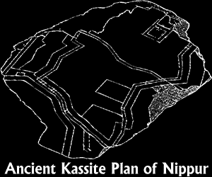
The site of Nippur measures about a mile in length and about a half mile in width. The city walls enclosed an area of about 135 hectares (almost 334 acres). About one fourth of the area within the city walls was devoted to impressive public buildings that attracted visitors from all over Sumer and Akkad. Outside the walls farmers cultivated the irrigated fields of grain and orchards. Pastoralists tended their flocks and herds.
Consider some comparisons on the dimensions of Nippur. Cuneiform reading courses are still being taught at the Homewood campus of the Johns Hopkins University on the East Coast of the United States (more specifically Baltimore, Maryland). Only learning to read is taught here and not learning to write, probably because the quality of the clay is not so good here in Baltimore. The prestigious Johns Hopkins University community only encompasses 140 acres, less than half the size of ancient Nippur. The university, however, is only a small part of the sprawling city of Baltimore, which covers over 50,000 acres (over 22,000 hectares).
The city of Nippur was extensively populated during the late third millennium B.C. when political affairs and economic life were centralized throughout the region under the authority of the city of Ur, a site down river a distance of a week or more. During these boom days under the patronage of the kings of Ur who gave considerable attention to Nippur as a religious center, the population may perhaps have reached forty thousand or so residents. This considerable population lacked the benefits and comforts of modern electricity-based technology. Later, in the eighteenth and nineteenth centuries B.C., however, the population had contracted in size somewhat. The extreme south-southwestern part of the west side of the city was left vacant.
Nippur already had a long tradition forty centuries ago. The site had been settled and continuously inhabited since about the forty-sixth century B.C., that is, sixty-six centuries before the present. Large temple establishments carried on the traditions and piety of Nippur. The religious quarter on the eastern side of the city was designated dur-an-ki, Sumerian for "the bond of heaven and earth."
This area was home to the worship of several major deities revered by the Sumerians and Akkadians. The head of the divine realm was Enlil. As the bestower of kingship, his recognition was crucial for any aspiring monarch. Beside his temple and kitchen stood a huge stepped tower with a shrine on the top stage. Such a tower was called a ziggurat. To see a plan of the area dedicated to the worship of Enlil, wander over to the Small Shrine for Enlil. Other examples of ziggurat architecture, dedicated to other deities, are known to us from other Mesopotamian cities such as Ur and Babylon.
Not far from the Enlil temple and ziggurat was the great temple devoted to the worship of the goddess Inanna. A temple for the great god Ninurta was also nearby, although we cannot yet pin down its exact location. On the west side of the city was a temple for the worship of the healing goddess Gula. Numerous administrators and priestly functionaries were kept busy caring for divine worship services and all the offerings of animals, bread and cake, and oil as well as votive objects of permanent value.
The ancient residents of Nippur were well acquainted with political instability and fragmentation in their cultural sphere. Political unity and centralized economy could be imposed across the region for several decades, but eventually centralized power eroded. Various power centers would compete for recognition by other more or less independent cities. Recognition was shown to these centers by using the official commemorative names they issued for each year of their king's reign. An era-type of dating system, such as our B.C./A.D. scheme, was not in use in the region before the fourth century B.C. adoption of the Seleucid era. In the early second millennium B.C., Nippur gave its recognition in this way (using commemorative sentence names issued by the royal court to designate the years) successively (more or less) to the power centers of Isin, Larsa, and Babylon. Nippur itself was never a royal capital.
Click on these links to navigate our site:


| Sign My Guestbook | View My Guestbook |
This page was edited on 1 January 2002. If you have cuneiform questions or comments, please email the Nippur Quay. You can also give a shout over to Dubsar's Sand Dune. Thanks! © 1997-2002 Erasmus Compositor, P.O. Box 25958, Baltimore, MD 21224.