|
| |
Chapter 3 Plate Tectonics - key points:
The key large scale, integrative theory for near-surface, geological
behaviour.
- What is it?
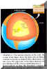
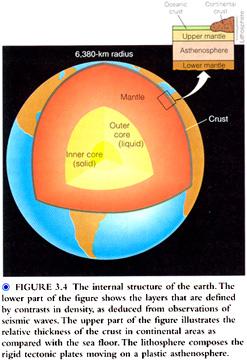
The outer ~70-80km (beneath the oceans) to ~100-150km (beneath the continents)
approximates a rigid external shell – called the lithosphere, which includes the
crust & part of the upper mantle.
But this external rigid shell is segmented; into plates.
Plate tectonics is simply the kinematic description of the relative motions of these
rigid parts of shells on the surface of the spherical Earth.
So let us go straight to Fig. 3.12, p.59: 7 large plates, and many smaller ones.
This map shows the average movement rate (cm/year) and the
relative motion of the tectonic plates.
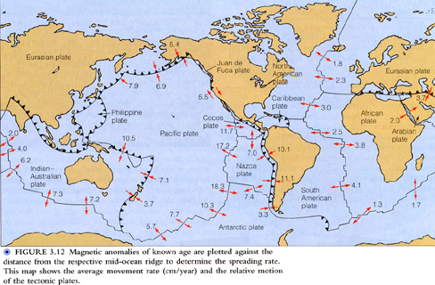
7 major plates.
- History - continental drift:
- Proposed by Alfred Wegener (1880 - 1930) in 1910 in Frankfurt; although there was
some precursor discussion: e.g. Antonio Snider - Pellegrini in the
C19 [1858], and even Abraham Ortelius(1527 - 98) in 1596.
- Key Examples of evidence:
- Mirror image fits of the coastlines on the opposite sides of the Atlantic (e.g. Fig.
3.15, p.61).
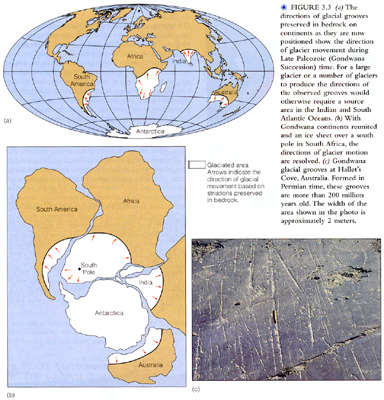
The distribution of ~245 - 286 MYR (Permian) glacial deposits in the southern
continents.
The distribution of a particular group of plant fossils in the southern continents (The
"Glossopteris" flora - see Fig. 3.2, p.52).
Wegener prepared 5 editions of his classic text: " The origin of continents and
oceans."
- More detailed description:
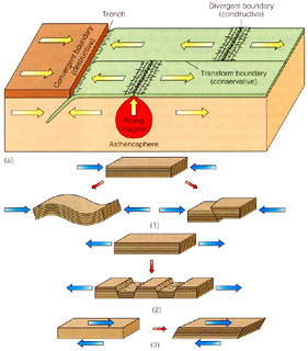
- Since plates are approx. internally rigid, all relative motion is concentrated at their
boundaries.
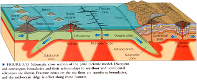
- There are 4 principal types of boundary, rather than 3, as the book describes (p.55):
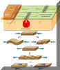
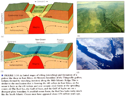
3.1 Divergent:
Sea floor spreading ridges:
e.g. Mid-Atlantic Ridge e.g. Iceland.
Some continental rifts:
e.g. East African rift valley.
Tension.
Sea floor spreading at rates of ~1.8 cm/yr/plate near Iceland to ~18.3
cm/yr/plate in the S. Pacific.
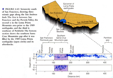
3.2 Transform, or strike slip:
Sub-horizontal, lateral motion along sub-vertical fault zones.
e.g. (in)famous San Andreas Fault system in California
e.g. p.110-111, 103-104
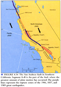
moved: 2m (Horizontally) + 1m (Vertically); magnitude 7.1 (see below)
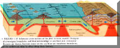
3.3 Convergent, subduction zone
boundaries:
- Relative to plate tectonic movement rates, the earth has a constant surface area. Hence,
since new oceanic crust is generated at sea-floor spreading ridges, oceanic crust must be
consumed at essentially the same rate in km�/yr.
- The surface expression is given by the great deep trenches of the world.
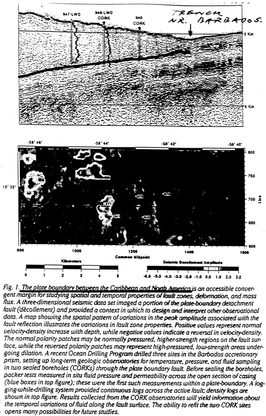
E.g. Barbados section.
These zones are called subduction zones (e.g. Fig. 3.5, p. 54) and are
marked by a zone of earthquakes dipping usually at ~ 60� to as deep as
~68km.
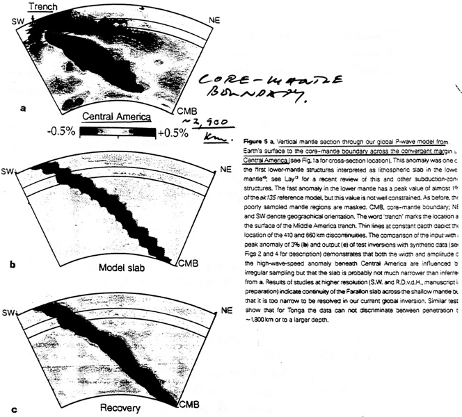
- These are the only locations where deep earthquakes (d> ~400km) occur.
- And it is now known from seismic (tomographic) imaging that subduction descends at least
~1600km, and that subducted slabs may accumulate on the mantle floor above
the core mantle boundary.
Click
here to view an article on the plate boundary between the Caribbean and North America.
Click
here to view an article on a vertical mantle section.
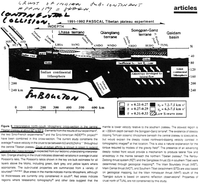
3.4 Convergent, collision zone
boundaries:
- Subduction of oceanic crust beneath continental crust, or other oceanic crust proceeds
smoothly.
- But, sooner or later leads to continent/continent collision, and the formation of
major mountain belts in the present, and, eroded, in the past.
e.g. Present:
- India/Asia collision => Himalayas.
- Africa/Europe collision => Alps.
Past:
- Appalachians – from Arkansas to Newfoundland; and then connecting (no
Atlantic) to Ireland, Scotland and Norway,Greenland. (~600 - 400 Myr).
- ~1Byr Grenville province: Gravenhurst - Tweed - Ottawa -->
Quebec.
Click here to view an article on the continental collision
between India and China.
- Major explanations:
Many: but one of the most important is why the general explanation for
the the following 4 phenomena tend to occur:
Associated.
In particular sinuous belts.
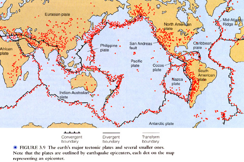
- Earthquakes:
Fig. 3.9, p. 57:
At: spreading ridges, transform faults (e.g. San Andreas), subduction
zones, and collision zones.
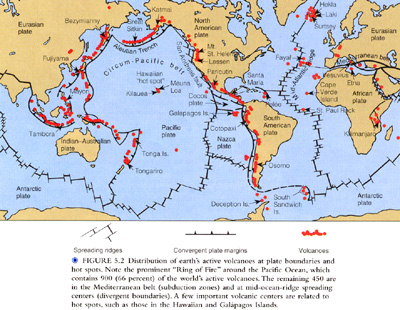
- Volcanoes:
Fig. 5.2, p.120
Particularly at: submarine spreading ridges, and above subduction zones,
Not so much - transform faults.
- Topographic elevations:
Particularly: 1. Submarine spreading ridges
2. Above subduction zones. E.g. Andes.
3. Collision zones e.g. Himalayas.
- Opposite - trenches - subduction zones!
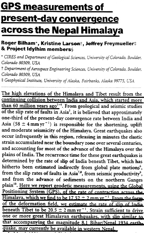
Verification/Quantification:
Direct measurement:
e.g. Laser ranging; global positioning surveys (GPS).
e.g. Rate of contraction across the Himalayas measured by
GPS to be:
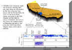
18 � 2 mm/yr (Bilham et al., 1997, Nature, v.386, p.61).
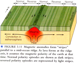
Dating magnetic anomaly stripes usually approx. symmetrical either
side of ridges.
Fig. 3.11, p.58.
Basis: Earth's magnetic field reverses polarity on a regular basis
e.g. 171 reversals in last 76 Myr.
Reversal time scale defined by radiometric dating of lavas of normal &
reversed polarity in sequence.
Click
here to view an article about GPS.
- Consequences:
Many, many:
Example:
The Wilson cycle (p.59); named after U. of T.
geophysicist, Prof. J.
Tuzo Wilson:
Evolutionary sequence of ocean formation, enlargement, closure, and
generation of major mountain belts. e.g. p. 60,61.
- E.g. In this general part of N. America:
- Grenville Prov. Wilson Cycle (~ 1 billion)
- Appalachian Prov. Wilson Cycle (~ 600 - 400 Myr).
- Present Atlantic Ocean - mid-cycle; since ~ 180 Myr. Subduction just starting
e.g. Caribbean Island Arc.
- New oceanic crust forms at ~ 2.8 km� per year!
Hence, over the past 3 billion yrs as many as 30 entire oceans may have
been created and destroyed!!!
Evolutionary
Stage |
Example |
Embryonic |
Rift valleys
of East Africa |
Youthful |
Gulf of
California. Red Sea |
Mature |
Atlantic
Ocean (growing larger) |
Declining |
Pacific Ocean
(becoming smaller) |
Terminal |
Mediterranean
Sea (closing, almost extinct) & mountain belt generation(e.g. Alps) |

5. Cause: Mantle convection
Spherical surface motions consequence of internal convective flow
of solid mantle by solid state flow in order to remove heat.
At last, progress is being made in:
- Imaging and modeling the internal flow pattern.
- Linking internal flow features to surface phenomena.
e.g. i. Hot plume below Iceland (Jan., 1997)
Such hot plumes may come from as deep as the core/mantle boundary.
- Subduction below central America to the core/mantle boundary!
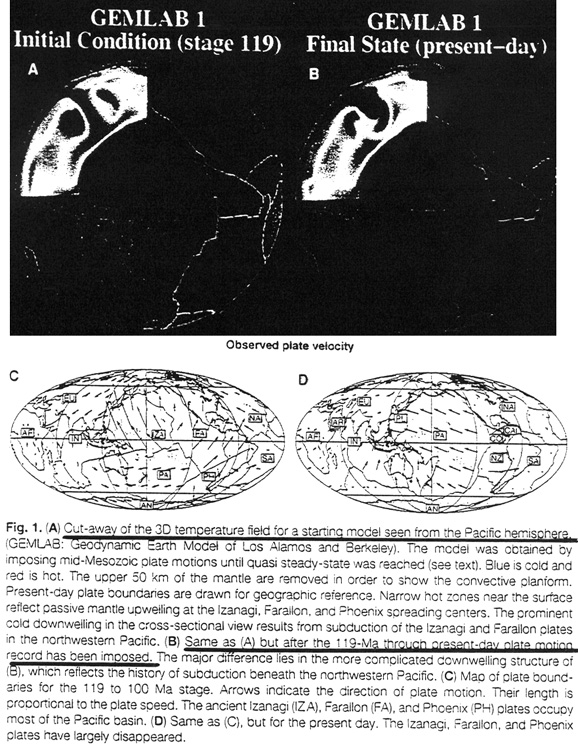
Click
here to view an article on Cut-away of the 3D temperature field.
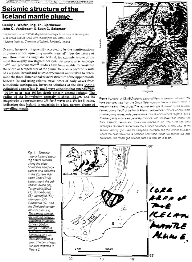
Click
here to view articles and pictures on seismic structure of the Iceland mantle
plume.
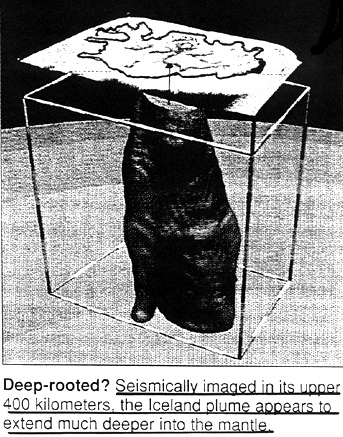
Click
here to view a 3D image of the Iceland plume.
|


